
File:Caves of Balakanche 2D map en.svg

Size of this PNG preview of this SVG file: 424 × 600 pixels. Other resolutions: 170 × 240 pixels | 339 × 480 pixels | 543 × 768 pixels | 724 × 1,024 pixels | 1,448 × 2,048 pixels | 744 × 1,052 pixels.
Original file (SVG file, nominally 744 × 1,052 pixels, file size: 81 KB)
| This is a file from the Wikimedia Commons. Information from its description page there is shown below. Commons is a freely licensed media file repository. You can help. |
Summary
| Description |
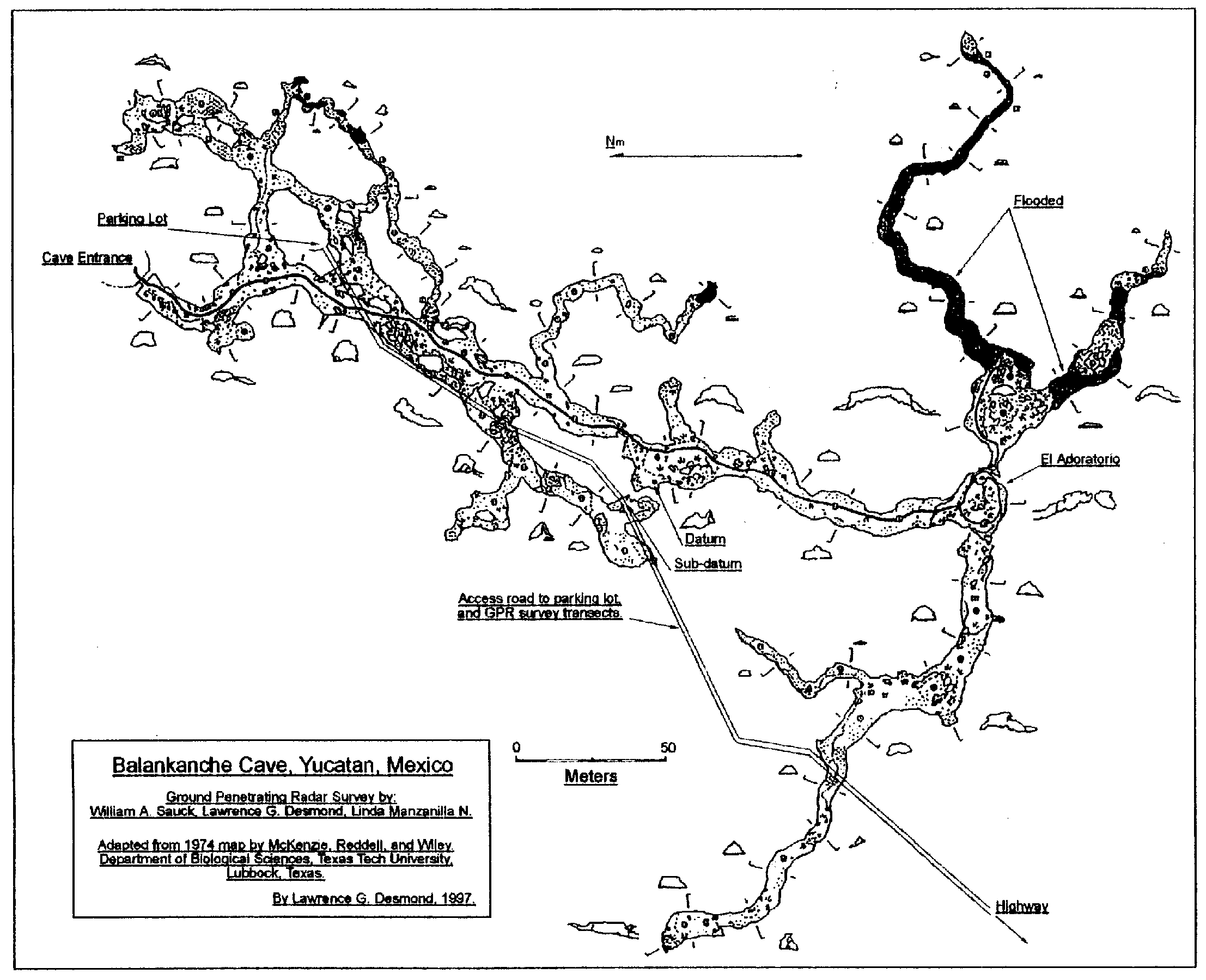
English: Caves of Balakanche 2D map, SVG format, A4 default size for printing. All corrections discussed at w:ru:Обсуждение:Баланканча#Карты. |
| Date | |
| Source |
|
| Author | Vectorization by NeoLexx, data preparation and translation by Strannik27 |
| Other versions |
Derivative works of this file: Caves of Balakanche 2D map ru.svg: |
Licensing
I, the copyright holder of this work, hereby publish it under the following license:
This file is licensed under the Creative Commons Attribution-Share Alike 3.0 Unported license.
- You are free:
- to share – to copy, distribute and transmit the work
- to remix – to adapt the work
- Under the following conditions:
- attribution – You must give appropriate credit, provide a link to the license, and indicate if changes were made. You may do so in any reasonable manner, but not in any way that suggests the licensor endorses you or your use.
- share alike – If you remix, transform, or build upon the material, you must distribute your contributions under the same or compatible license as the original.
File history
Click on a date/time to view the file as it appeared at that time.
| Date/Time | Thumbnail | Dimensions | User | Comment | |
|---|---|---|---|---|---|
| current | 19:37, 5 April 2013 | | 744 × 1,052 (81 KB) | Neolexx | Minor corrections, muddy and partially flooded areas marked. |
| 14:40, 3 April 2013 |  | 744 × 1,052 (48 KB) | Neolexx | Minor corrections | |
| 17:50, 29 March 2013 |  | 744 × 1,052 (47 KB) | Neolexx | Different corrections and improvements upon the discussion. | |
| 11:15, 28 March 2013 |  | 744 × 1,052 (41 KB) | Neolexx | {{Information |Description ={{en|1=Caves of Balakanche 2D map, SVG format, A4 default size for printing.}} |Source =* Cartographic data: from [http://www.latinamericanstudies.org/chichen/Balankanche-map.GIF 1997 map], adapted from 1974 map b... |
File usage
The following pages on the English Wikipedia use this file (pages on other projects are not listed):
Global file usage
The following other wikis use this file:
- Usage on ar.wikipedia.org
- Usage on es.wikipedia.org
- Usage on mk.wikipedia.org