
File:Chester-le-Street- The Finchale End (geograph 6900908).jpg

Size of this preview: 800 × 600 pixels. Other resolutions: 320 × 240 pixels | 640 × 480 pixels | 1,024 × 768 pixels | 1,200 × 900 pixels.
Original file (1,200 × 900 pixels, file size: 961 KB, MIME type: image/jpeg)
| This is a file from the Wikimedia Commons. Information from its description page there is shown below. Commons is a freely licensed media file repository. You can help. |
.jpg)
Summary
| Description |
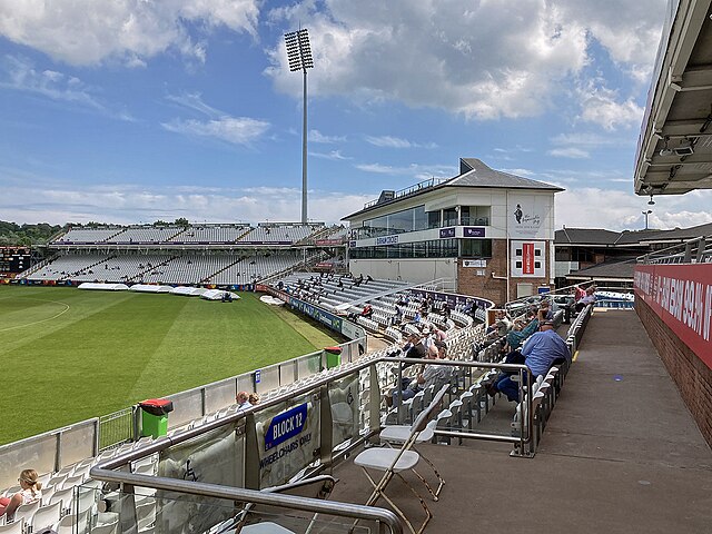
English: In this view from the southern end of the Don Robson Pavilion at the Durham County Cricket Ground, the Media Centre at the Finchale End is just to the right of centre, with the double-decker County Durham Stand to the left. The picture was taken during the lunch interval of a County Championship match. Because of the coronavirus pandemic spectators were observing social distancing and wearing masks when away from their seats. |
| Date | |
| Source | From geograph.org.uk |
| Author | John Sutton |
| Permission (Reusing this file) |
Creative Commons Attribution Share-alike license 2.0 |
| Attribution (required by the license) | John Sutton / Chester-le-Street: The Finchale End / |
| Camera location | | View this and other nearby images on: OpenStreetMap |
|---|
.jpg¶ms=054.848874_N_-001.561878_E_globe:Earth_type:camera_source:geograph-osgb36(NZ28235054)_heading:90.00&language=en)
| Object location | | View this and other nearby images on: OpenStreetMap |
|---|
.jpg¶ms=054.848870_N_-001.560630_E_globe:Earth_class:object_type:object_source:geograph-osgb36(NZ28315054)_heading:90.00&language=en)
Licensing

|
This image was taken from the Geograph project collection. See this photograph's page on the Geograph website for the photographer's contact details. The copyright on this image is owned by John Sutton and is licensed for reuse under the Creative Commons Attribution-ShareAlike 2.0 license.
|
This file is licensed under the Creative Commons Attribution-Share Alike 2.0 Generic license.
Attribution: John Sutton
- You are free:
- to share – to copy, distribute and transmit the work
- to remix – to adapt the work
- Under the following conditions:
- attribution – You must give appropriate credit, provide a link to the license, and indicate if changes were made. You may do so in any reasonable manner, but not in any way that suggests the licensor endorses you or your use.
- share alike – If you remix, transform, or build upon the material, you must distribute your contributions under the same or compatible license as the original.
File history
Click on a date/time to view the file as it appeared at that time.
| Date/Time | Thumbnail | Dimensions | User | Comment | |
|---|---|---|---|---|---|
| current | 16:49, 4 May 2023 | | 1,200 × 900 (961 KB) | Chocolateediter | == {{int:filedesc}} == {{Information |Description={{en|1=In this view from the southern end of the Don Robson Pavilion at the Durham County Cricket Ground, the Media Centre at the Finchale End is just to the right of centre, with the double-decker County Durham Stand to the left. The picture was taken during the lunch interval of a County Championship match. Because of the coronavirus pandemic spectators were observing social distancing and wearing masks when away from their seats.}} |Source=... |
File usage
The following pages on the English Wikipedia use this file (pages on other projects are not listed):
.jpg)