
File:Chesterfield Market Place station location geograph-3323702-by-Ben-Brooksbank.jpg

Size of this preview: 800 × 503 pixels. Other resolutions: 320 × 201 pixels | 640 × 403 pixels | 1,024 × 644 pixels | 1,280 × 805 pixels | 2,395 × 1,507 pixels.
Original file (2,395 × 1,507 pixels, file size: 2.85 MB, MIME type: image/jpeg)
| This is a file from the Wikimedia Commons. Information from its description page there is shown below. Commons is a freely licensed media file repository. You can help. |
Summary
| Description |
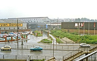
English: SW view towards site of Chesterfield Market Place station, 1988. Market Place station was the western terminus of the ex-Lancashire, Derbyshire & East Coast section of the former Great Central Railway, which until December 1951 ran from here eastwards via Shirebrook (Langwith Junction) and Tuxford to Lincoln (Pyewipe Junction). After that date, trains ran only from Shirebrook to Lincoln, passenger trains until 19/9/55, but freight until the 1990s - even to the present day over some sections. The view is from a footbridge - no longer in existence - beside the ex-Midland main line by the (former) Horns Bridge Box, south of the present Chesterfield station and by the present A61, where the LD&EC line had been carried on a high viaduct over the Midland and the Great Central lines. [I owe much to David Robinson for helping in the location of this scene, which has changed out of all recognition, not only between 1951 and 1988 but since 1988]. |
| Date | |
| Source | From geograph.org.uk |
| Author | Ben Brooksbank |
| Permission (Reusing this file) |
Creative Commons Attribution Share-alike license 2.0 |
| Attribution (required by the license) | Ben Brooksbank / SW view towards site of Chesterfield Market Place station, 1988 / |
| Camera location | | View this and other nearby images on: OpenStreetMap |
|---|
Licensing

|
This image was taken from the Geograph project collection. See this photograph's page on the Geograph website for the photographer's contact details. The copyright on this image is owned by Ben Brooksbank and is licensed for reuse under the Creative Commons Attribution-ShareAlike 2.0 license.
|
This file is licensed under the Creative Commons Attribution-Share Alike 2.0 Generic license.
Attribution: Ben Brooksbank
- You are free:
- to share – to copy, distribute and transmit the work
- to remix – to adapt the work
- Under the following conditions:
- attribution – You must give appropriate credit, provide a link to the license, and indicate if changes were made. You may do so in any reasonable manner, but not in any way that suggests the licensor endorses you or your use.
- share alike – If you remix, transform, or build upon the material, you must distribute your contributions under the same or compatible license as the original.
File history
Click on a date/time to view the file as it appeared at that time.
| Date/Time | Thumbnail | Dimensions | User | Comment | |
|---|---|---|---|---|---|
| current | 16:33, 15 February 2013 | | 2,395 × 1,507 (2.85 MB) | Chevin | == {{int:filedesc}} == {{Information |Description={{en|1='''SW view towards site of Chesterfield Market Place station, 1988.'''<br/> Market Place station was the western terminus of the ex-Lancashire, Derbyshire & East Coast section of the former Grea... |
File usage
The following pages on the English Wikipedia use this file (pages on other projects are not listed):