
File:Coal-creek-war-map-tn1.jpg
No higher resolution available.
Coal-creek-war-map-tn1.jpg (410 × 270 pixels, file size: 21 KB, MIME type: image/jpeg)
| This is a file from the Wikimedia Commons. Information from its description page there is shown below. Commons is a freely licensed media file repository. You can help. |
Summary
| Description |
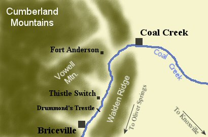
English: Map showing key locations of the Coal Creek War in the Coal Creek area of western Anderson County, Tennessee.
|
| Date | |
| Source | Own work |
| Author | Brian Stansberry |
Licensing
I, the copyright holder of this work, hereby publish it under the following license:
This file is licensed under the Creative Commons Attribution 3.0 Unported license.
- You are free:
- to share – to copy, distribute and transmit the work
- to remix – to adapt the work
- Under the following conditions:
- attribution – You must give appropriate credit, provide a link to the license, and indicate if changes were made. You may do so in any reasonable manner, but not in any way that suggests the licensor endorses you or your use.
File history
Click on a date/time to view the file as it appeared at that time.
| Date/Time | Thumbnail | Dimensions | User | Comment | |
|---|---|---|---|---|---|
| current | 13:46, 8 May 2009 | | 410 × 270 (21 KB) | BrineStans | {{Information |Description={{en|1=The Coal Creek area of western Anderson County, Tennessee, USA, showing key locations of the Coal Creek War, a coal miners' uprising in the early 1890s. Most of the events took place in the vicinity of Briceville and Coa |
File usage
The following pages on the English Wikipedia use this file (pages on other projects are not listed):
Global file usage
The following other wikis use this file:
- Usage on sr.wikipedia.org
- Usage on www.wikidata.org