
File:Columbia Island - aerial view 2005.jpg
Columbia_Island_-_aerial_view_2005.jpg (473 × 406 pixels, file size: 240 KB, MIME type: image/jpeg)
| This is a file from the Wikimedia Commons. Information from its description page there is shown below. Commons is a freely licensed media file repository. You can help. |
Summary
| Description |
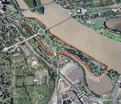
English: Aerial view of Columbia Island (outlined in red) in the Potomac River in Washington, D.C., in the United States.
Arlington Memorial Bridge enters the island from the northeast, connecting it to the Lincoln Memorial. A large memorial plaza and traffic circle, constructed in the 1930s, connects Arlington Memorial Bridge to Lee Highway, the George Washington Memorial Parkway, and the Boundary Channel Bridge. The many piers of the Columbia Island Marina jut into the Bounday Channel and Pentagon Lagoon on the southwest corner of the island. The Potomac River runs along the island to the northwest. The Lincoln Memorial and a portion of the Tidal Basin can also be seen. The Boundary Channel (west and southwest of the island) is part of the Potomac River. The Boundary Channel Bridge links Columbia Island to Memorial Drive and the ceremonial entrance to Arlington National Cemetery (left side of the image). The Pentagon can be seen to the bottom of the image, and just north of that its large parking lots. Upstream (upper center portion of this image) is the Theodore Roosevelt Bridge, and Theodore Roosevelt Island. The skyscrapers of Rossyln, Virginia, can just be seen in the far upper left corner of the image. |
| Date | |
| Source | File:Washington_77.04477W_38.88819N.jpg |
| Author | NASA |
| This file is in the public domain in the United States because it was solely created by NASA. NASA copyright policy states that "NASA material is not protected by copyright unless noted". (See Template:PD-USGov, NASA copyright policy page or JPL Image Use Policy.) | ||
 |
Warnings:
|
Licensing
File history
Click on a date/time to view the file as it appeared at that time.
| Date/Time | Thumbnail | Dimensions | User | Comment | |
|---|---|---|---|---|---|
| current | 18:23, 6 May 2013 | | 473 × 406 (240 KB) | Tim1965 | {{Information |Description ={{en|1=Aerial view of Columbia Island (outlined in red) in the Potomac River in Washington, D.C., in the United States. Arlington Memorial Bridge enters the island from the northeast, connecting it to the Lincoln Memoria... |
File usage
Global file usage
The following other wikis use this file:
- Usage on ceb.wikipedia.org
- Usage on fr.wikipedia.org
- Usage on he.wikipedia.org
- Usage on ur.wikipedia.org
- Usage on www.wikidata.org