
File:Columbia River and West Bar Giant Ripples - Flickr - brewbooks (1).jpg

Size of this preview: 800 × 451 pixels. Other resolutions: 320 × 180 pixels | 640 × 361 pixels | 1,024 × 577 pixels | 1,280 × 721 pixels | 2,560 × 1,442 pixels | 4,288 × 2,416 pixels.
Original file (4,288 × 2,416 pixels, file size: 4.86 MB, MIME type: image/jpeg)
| This is a file from the Wikimedia Commons. Information from its description page there is shown below. Commons is a freely licensed media file repository. You can help. |
.jpg)
Summary
| Description |
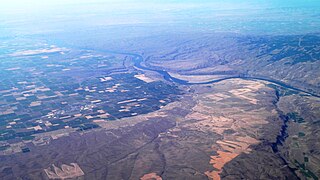
Giant ripples of the West Bar - which were formed as part Ice Age Floods when Glacial Lake Missoula let go about 12,000 years ago. My introduction to this whole phenomena was through another book (of course!) Allen, John Eliot; Burns, Marjorie and Sargent, Sam C. (c1986). Cataclysms on the Columbia : a layman's guide to the features produced by the catastrophic Bretz floods in the Pacific Northwest. Portland, OR: Timber Press listorama got me out there (relatively safely) on a remarkable 2 day trip to explore some geology. Link to listorama West Bar 2008 photos12q3 296 |
| Date | |
| Source | Columbia River and West Bar Giant Ripples |
| Author | brewbooks from near Seattle, USA |
| Camera location | | View this and other nearby images on: OpenStreetMap |
|---|
.jpg¶ms=047.397935_N_-120.062509_E_globe:Earth_type:camera_source:Flickr_&language=en)
Licensing
This file is licensed under the Creative Commons Attribution-Share Alike 2.0 Generic license.
- You are free:
- to share – to copy, distribute and transmit the work
- to remix – to adapt the work
- Under the following conditions:
- attribution – You must give appropriate credit, provide a link to the license, and indicate if changes were made. You may do so in any reasonable manner, but not in any way that suggests the licensor endorses you or your use.
- share alike – If you remix, transform, or build upon the material, you must distribute your contributions under the same or compatible license as the original.
| This image was originally posted to Flickr by brewbooks at https://flickr.com/photos/93452909@N00/8070978253. It was reviewed on 22 October 2016 by FlickreviewR and was confirmed to be licensed under the terms of the cc-by-sa-2.0. |
File history
Click on a date/time to view the file as it appeared at that time.
| Date/Time | Thumbnail | Dimensions | User | Comment | |
|---|---|---|---|---|---|
| current | 05:31, 22 October 2016 | | 4,288 × 2,416 (4.86 MB) | Josve05a | == {{int:filedesc}} == {{Information |Description=Giant ripples of the West Bar - which were formed as part [http://www.iafi.org/floods.html Ice Age Floods] when [http://en.wikipedia.org/wiki/Lake_Missoula Glacial Lake Missoula] let go about 12,000 ye... |
File usage
The following pages on the English Wikipedia use this file (pages on other projects are not listed):
.jpg)