
File:Dartmoor topographic map.svg

Size of this PNG preview of this SVG file: 610 × 599 pixels. Other resolutions: 244 × 240 pixels | 489 × 480 pixels | 782 × 768 pixels | 1,043 × 1,024 pixels | 2,086 × 2,048 pixels | 2,000 × 1,964 pixels.
Original file (SVG file, nominally 2,000 × 1,964 pixels, file size: 15.26 MB)
| This is a file from the Wikimedia Commons. Information from its description page there is shown below. Commons is a freely licensed media file repository. You can help. |
Summary
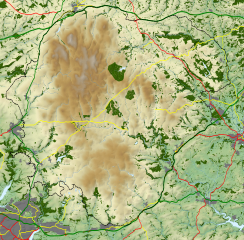
| Description | Topographic map of Dartmoor National Park, showing roads, water, woods and towns. |
| Date | |
| Source |
|
| Author | Nilfanion, using Ordnance Survey data |
Licensing
I, the copyright holder of this work, hereby publish it under the following license:
This file is licensed under the Creative Commons Attribution-Share Alike 3.0 Unported license.
- You are free:
- to share – to copy, distribute and transmit the work
- to remix – to adapt the work
- Under the following conditions:
- attribution – You must give appropriate credit, provide a link to the license, and indicate if changes were made. You may do so in any reasonable manner, but not in any way that suggests the licensor endorses you or your use.
- share alike – If you remix, transform, or build upon the material, you must distribute your contributions under the same or compatible license as the original.
File history
Click on a date/time to view the file as it appeared at that time.
| Date/Time | Thumbnail | Dimensions | User | Comment | |
|---|---|---|---|---|---|
| current | 10:57, 1 October 2011 | | 2,000 × 1,964 (15.26 MB) | Nilfanion | +relief shading, tweaking town/wood colours |
| 10:13, 31 August 2011 |  | 2,000 × 1,964 (16.33 MB) | Nilfanion | {{Information |Description=Topographic map of Dartmoor National Park, showing roads, water, woods and towns. |Source=Ordnance Survey [https://www.ordnancesurvey.co.uk/opendatadownload/products.html OpenData]. *Contour data from Land |
File usage
No pages on the English Wikipedia use this file (pages on other projects are not listed).
Global file usage
The following other wikis use this file:
- Usage on cs.wikipedia.org