
File:Dothan.svg

Size of this PNG preview of this SVG file: 594 × 599 pixels. Other resolutions: 238 × 240 pixels | 476 × 480 pixels | 761 × 768 pixels | 1,015 × 1,024 pixels | 2,030 × 2,048 pixels | 1,848 × 1,864 pixels.
Original file (SVG file, nominally 1,848 × 1,864 pixels, file size: 188 KB)
| This is a file from the Wikimedia Commons. Information from its description page there is shown below. Commons is a freely licensed media file repository. You can help. |
| This work has been released into the public domain by its author, SPUI. This applies worldwide. In some countries this may not be legally possible; if so: |
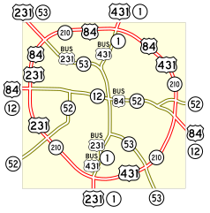
Map of numbered routes in Dothan, Alabama. Traced on USGS topos.
- Red: U.S. Routes
- Yellow: State Routes
If you need a thumbnail use Image:Dothan.png.
File history
Click on a date/time to view the file as it appeared at that time.
| Date/Time | Thumbnail | Dimensions | User | Comment | |
|---|---|---|---|---|---|
| current | 11:18, 17 May 2006 | | 1,848 × 1,864 (188 KB) | SPUI~commonswiki | {{spuimap}} Map of numbered routes in Dothan, Alabama. Traced on USGS topos. *Red: U.S. Routes *Yellow: State Routes If you need a thumbnail use Image:Dothan.png. Category:road maps Category:Dothan, Alabama |
File usage
The following pages on the English Wikipedia use this file (pages on other projects are not listed):
Global file usage
The following other wikis use this file:
- Usage on ja.wikipedia.org
- Usage on www.wikidata.org