
File:EF2 tornado damage to a wind turbine near Carl, Iowa.jpg

Size of this preview: 800 × 600 pixels. Other resolutions: 320 × 240 pixels | 640 × 480 pixels | 1,024 × 768 pixels | 1,280 × 960 pixels | 2,560 × 1,920 pixels | 4,080 × 3,060 pixels.
Original file (4,080 × 3,060 pixels, file size: 956 KB, MIME type: image/jpeg)
| This is a file from the Wikimedia Commons. Information from its description page there is shown below. Commons is a freely licensed media file repository. You can help. |
Summary
| Description |
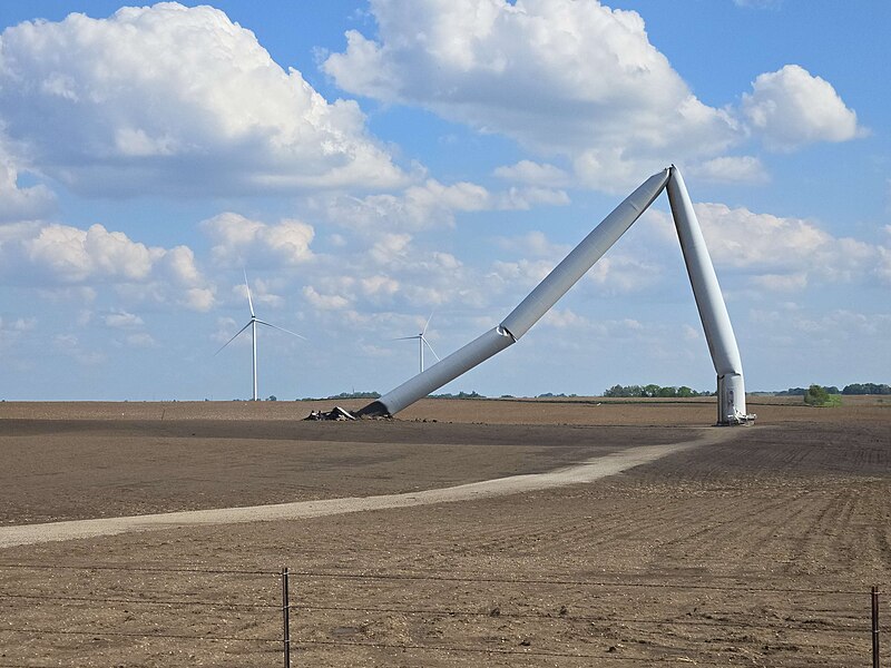
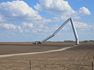
English: EF2 tornado damage to a wind turbine that had caught fire near Carl, Iowa. |
| Date | |
| Source | https://apps.dat.noaa.gov/StormDamage/DamageViewer/ |
| Author | National Oceanic and Atmospheric Administration |
| Camera location | | View this and other nearby images on: OpenStreetMap |
|---|
Licensing
This image is in the public domain because it contains materials that originally came from the U.S. National Oceanic and Atmospheric Administration, taken or made as part of an employee's official duties.
|
File history
Click on a date/time to view the file as it appeared at that time.
| Date/Time | Thumbnail | Dimensions | User | Comment | |
|---|---|---|---|---|---|
| current | 03:41, 4 July 2024 | | 4,080 × 3,060 (956 KB) | Nicholas Krasznavolgyi | Uploaded a work by National Oceanic and Atmospheric Administration from https://apps.dat.noaa.gov/StormDamage/DamageViewer/ with UploadWizard |
File usage
The following pages on the English Wikipedia use this file (pages on other projects are not listed):