
File:Elm Grove Stone Arch Bridge.jpg

Size of this preview: 800 × 505 pixels. Other resolutions: 320 × 202 pixels | 640 × 404 pixels | 1,024 × 646 pixels | 1,280 × 808 pixels | 1,973 × 1,245 pixels.
Original file (1,973 × 1,245 pixels, file size: 444 KB, MIME type: image/jpeg)
| This is a file from the Wikimedia Commons. Information from its description page there is shown below. Commons is a freely licensed media file repository. You can help. |
|
This is an image of a place or building that is listed on the National Register of Historic Places in the United States of America. Its reference number is 81000606. |
| Description |
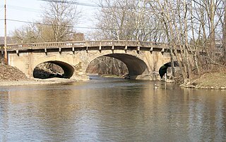
English: The Elm Grove Stone Arch Bridge carrying National Road (U.S. Rte 40) over Wheeling Creek in Elm Grove, West Virginia. The bridge is photographed from its western facade. The bridge is listed on the NRHP in 1981. Taken April 2, 2010. |
| Date | |
| Source |
I (Bwsmith84 (talk)) created this work entirely by myself. Transferred from en.wikipedia |
| Author | Bwsmith84 (talk) |
| Permission (Reusing this file) |
Bwsmith84 at en.wikipedia, the copyright holder of this work, hereby publishes it under the following license: This file is licensed under the Creative Commons Attribution 3.0 Unported license. Attribution: Bwsmith84 at en.wikipedia
|
| Object location | | View this and other nearby images on: OpenStreetMap |
|---|
Original upload log
The original description page was here. All following user names refer to en.wikipedia.
- 2010-04-04 04:09 Bwsmith84 1973×1245 (454626 bytes) {{Information |Description = The Elm Grove Stone Arch Bridge carrying National Road (U.S. Rte 40) over Wheeling Creek in Elm Grove, West Virginia. The bridge is photographed from its western facade. The bridge is listed on the NRHP in 1981. Taken Apri
File history
Click on a date/time to view the file as it appeared at that time.
| Date/Time | Thumbnail | Dimensions | User | Comment | |
|---|---|---|---|---|---|
| current | 21:18, 8 January 2012 | | 1,973 × 1,245 (444 KB) | BotMultichillT | {{BotMoveToCommons|en.wikipedia|year={{subst:CURRENTYEAR}}|month={{subst:CURRENTMONTHNAME}}|day={{subst:CURRENTDAY}}}} == {{int:filedesc}} == {{Information |description={{en|1=The Elm Grove Stone Arch Bridge carrying National Road (U.S. Rte 40) over Whee |
File usage
The following pages on the English Wikipedia use this file (pages on other projects are not listed):
Global file usage
The following other wikis use this file:
- Usage on www.wikidata.org