
File:FairfaxLine.jpg

Size of this preview: 399 × 599 pixels. Other resolutions: 160 × 240 pixels | 320 × 480 pixels | 512 × 768 pixels | 682 × 1,024 pixels | 1,460 × 2,191 pixels.
Original file (1,460 × 2,191 pixels, file size: 2.11 MB, MIME type: image/jpeg)
| This is a file from the Wikimedia Commons. Information from its description page there is shown below. Commons is a freely licensed media file repository. You can help. |
Summary
| Description |
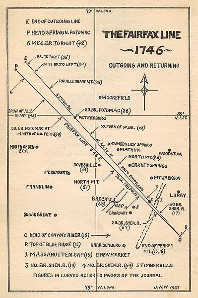
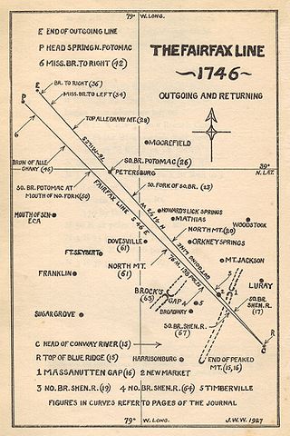
English: Map of the Fairfax Line of Virginia and West Virginia, surveyed 1746. |
| Date | |
| Source | The Fairfax Line: Thomas Lewis's Journal of 1746; Footnotes and index by John Wayland, Newmarket, Virginia: The Henkel Press (1925 publication), pg 14. |
| Author | John W. Wayland |
| Permission (Reusing this file) |
Copyright expired; Older than 1928. |
Source book published 1925, but date on map is 1927 (?).
Licensing
|
This work is in the public domain in its country of origin and other countries and areas where the copyright term is the author's life plus 70 years or fewer. | |
| This file has been identified as being free of known restrictions under copyright law, including all related and neighboring rights. | |
File history
Click on a date/time to view the file as it appeared at that time.
| Date/Time | Thumbnail | Dimensions | User | Comment | |
|---|---|---|---|---|---|
| current | 13:46, 1 February 2009 | | 1,460 × 2,191 (2.11 MB) | Valerius Tygart | {{Information |Description={{en|1=Map of the Fairfax Line of Virginia and West Virginia, surveyed 1746. Source: ''The Fairfax Line: Thomas Lewis's Journal of 1746''; Footnotes and index by John Wayland, Newmarket, Virginia: The Henkel Press (1925 reprint |
File usage
The following page uses this file: