File:GOES-16 first GLM data.jpg

Page contents not supported in other languages.
This is a file from the Wikimedia Commons
From Wikipedia, the free encyclopedia

Original file(928 × 775 pixels, file size: 87 KB, MIME type: image/jpeg)

Summary

Description
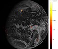
English: GOES-16 Geostationary Lightning Mapper (GLM) lightning data accumulated over one hour, during which GLM acquired 1.8 million images of the Earth, is displayed over Advanced Baseline Imager (ABI) full disk Band 2 imagery on the afternoon of February 14, 2017. Brighter colors indicate more lightning energy was recorded; color bar units are the calculated kilowatt-hours of total optical emissions from lightning. The brightest storm system is located over the Gulf Coast of Texas, the same storm system in the accompanying video. GLM is able to detect lightning equally well over the entire full disk, including oceans and sparsely populated areas. Coverage of the oceans enables more timely and reliable severe weather forecasts for aircraft traveling oceanic routes where no weather radar coverage is available and for maritime shipping across the entire Western Hemisphere.
Date
Source https://www.flickr.com/photos/noaasatellites/32394459783
Author NOAA/NASA

Licensing

Public domain This file is in the public domain in the United States because it was solely created by NASA. NASA copyright policy states that "NASA material is not protected by copyright unless noted". (See Template:PD-USGov, NASA copyright policy page or JPL Image Use Policy.)
Warnings:

Captions

Add a one-line explanation of what this file represents

Items portrayed in this file

depicts

2 March 2017

image/jpeg

File history

Click on a date/time to view the file as it appeared at that time.

Date/TimeThumbnailDimensionsUserComment
current18:02, 15 April 2018Thumbnail for version as of 18:02, 15 April 2018928 × 775 (87 KB)TheAustinManUser created page with UploadWizard
The following pages on the English Wikipedia use this file (pages on other projects are not listed):

Metadata