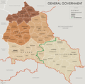
File:General Government for the occupied Polish territories (1941).png

Size of this preview: 605 × 600 pixels. Other resolutions: 242 × 240 pixels | 484 × 480 pixels | 774 × 768 pixels | 1,033 × 1,024 pixels | 2,299 × 2,280 pixels.
Original file (2,299 × 2,280 pixels, file size: 543 KB, MIME type: image/png)
File history
Click on a date/time to view the file as it appeared at that time.
| Date/Time | Thumbnail | Dimensions | User | Comment | |
|---|---|---|---|---|---|
| current | 15:33, 8 May 2014 |  | 2,299 × 2,280 (543 KB) | Poeticbent | legend |
| 16:48, 18 March 2014 |  | 2,299 × 2,280 (453 KB) | Poeticbent | =={{int:filedesc}}== {{Information |description={{en|1=Map of the administrative areas of the General Government}} |date=2012-05-26 |source={{own}} by {{u|XrysD}}, edited by {{u|Poeticbent}} with superimposed German-Soviet border before Operation Barba... |
File usage
The following pages on the English Wikipedia use this file (pages on other projects are not listed):
Global file usage
The following other wikis use this file:
- Usage on ar.wikipedia.org
- Usage on azb.wikipedia.org
- Usage on es.wikipedia.org
- Usage on fr.wikipedia.org
- Usage on it.wikipedia.org
- Usage on no.wikipedia.org
- Usage on pl.wikipedia.org
- Usage on pt.wikipedia.org
- Usage on ru.wikipedia.org
- Usage on www.wikidata.org
- Usage on zh.wikipedia.org

