
File:Geographic map of Somaliland.svg

Size of this PNG preview of this SVG file: 800 × 506 pixels. Other resolutions: 320 × 202 pixels | 640 × 405 pixels | 1,024 × 648 pixels | 1,280 × 810 pixels | 2,560 × 1,619 pixels | 4,110 × 2,600 pixels.
Original file (SVG file, nominally 4,110 × 2,600 pixels, file size: 11.09 MB)
| This is a file from the Wikimedia Commons. Information from its description page there is shown below. Commons is a freely licensed media file repository. You can help. |
Summary
| Description |
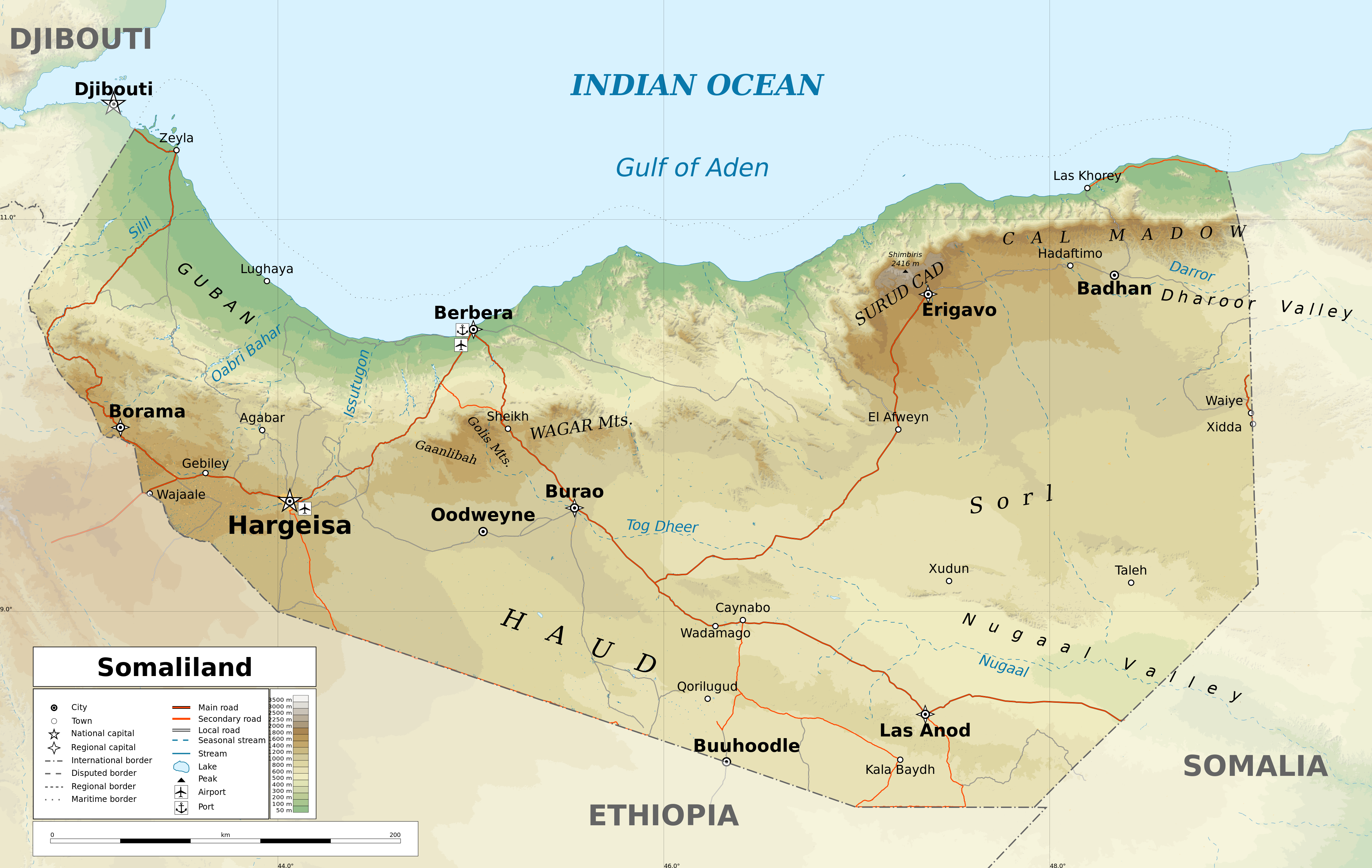
English: Geographic map of Somaliland. Geographic limits of the map:
|
| Date | |
| Source |
Own work
|
| Author | Ikonact |
| Permission (Reusing this file) |
Any use of this map is subject of the license(s) stated below with the condition that you credit (Wikimedia Commons user: Ikonact) as the author . A message with a reply address would also be greatly appreciated. |
| Other versions |
[]
|
| SVG development |


Assessment
|
Licensing
I, the copyright holder of this work, hereby publish it under the following license:
This file is licensed under the Creative Commons Attribution-Share Alike 4.0 International license.
- You are free:
- to share – to copy, distribute and transmit the work
- to remix – to adapt the work
- Under the following conditions:
- attribution – You must give appropriate credit, provide a link to the license, and indicate if changes were made. You may do so in any reasonable manner, but not in any way that suggests the licensor endorses you or your use.
- share alike – If you remix, transform, or build upon the material, you must distribute your contributions under the same or compatible license as the original.
File history
Click on a date/time to view the file as it appeared at that time.
| Date/Time | Thumbnail | Dimensions | User | Comment | |
|---|---|---|---|---|---|
| current | 17:20, 13 February 2022 | | 4,110 × 2,600 (11.09 MB) | Jacob300 | Reverted to version as of 22:29, 26 August 2021 (UTC) |
| 08:01, 27 August 2021 |  | 4,110 × 2,600 (11.27 MB) | Ikonact | Reverted to version as of 11:59, 26 August 2021 (UTC) - the eastern border is disputed and should stay as such | |
| 22:29, 26 August 2021 |  | 4,110 × 2,600 (11.09 MB) | Siirski | Corrected eastern border | |
| 11:59, 26 August 2021 |  | 4,110 × 2,600 (11.27 MB) | Ikonact | final touch | |
| 09:37, 26 August 2021 |  | 4,110 × 2,600 (11.36 MB) | Ikonact | legend, names in En | |
| 20:47, 25 August 2021 |  | 4,110 × 2,600 (11.33 MB) | Ikonact | + mnts nammes | |
| 20:07, 25 August 2021 |  | 4,110 × 2,600 (11.32 MB) | Ikonact | font | |
| 20:03, 25 August 2021 |  | 4,110 × 2,600 (11.32 MB) | Ikonact | more data | |
| 12:56, 24 August 2021 |  | 4,110 × 2,600 (16.17 MB) | Ikonact | == {{int:filedesc}} == {{Information |description={{en|Geographic map of {{W|Somaliland}}. Geographic limits of the map:}} *N: 12.12° N *S: 7.69° N *W: 42.56° E *E: 49.67° E Equidistant Cylindrical projection; WGS 84 datum |date=2021-08-24 |source={{own}} *Sources of data:<br/> **Topography: SRTM3 v4 (public domain);<br/> **Rivers and water bodies: Natural Earth, © OpenStreetMap contributors **Borders and towns: © OpenStreetMap contributors;<br/> *Tool:<br/> **The map is created with Octave s... |
File usage
The following pages on the English Wikipedia use this file (pages on other projects are not listed):
Global file usage
The following other wikis use this file:
- Usage on ar.wikipedia.org
- Usage on bg.wikipedia.org
- Usage on ca.wikipedia.org
- Usage on da.wikipedia.org
- Usage on de.wikipedia.org
- Usage on fr.wikipedia.org
- Usage on ga.wikipedia.org
- Usage on gl.wikipedia.org
- Usage on hu.wikipedia.org
- Usage on id.wikipedia.org
- Usage on is.wikipedia.org
- Usage on ja.wikipedia.org
- Usage on ku.wikipedia.org
- Usage on lt.wikipedia.org
- Usage on ru.wikivoyage.org
- Usage on sh.wikipedia.org
- Usage on so.wikipedia.org
- Usage on sv.wikipedia.org
- Usage on www.wikidata.org
- Usage on zh.wikipedia.org