
File:Gila NF Wilderness Map.jpg
Size of this preview: 463 × 599 pixels. Other resolutions: 185 × 240 pixels | 541 × 700 pixels.
Original file (541 × 700 pixels, file size: 83 KB, MIME type: image/jpeg)
| This is a file from the Wikimedia Commons. Information from its description page there is shown below. Commons is a freely licensed media file repository. You can help. |
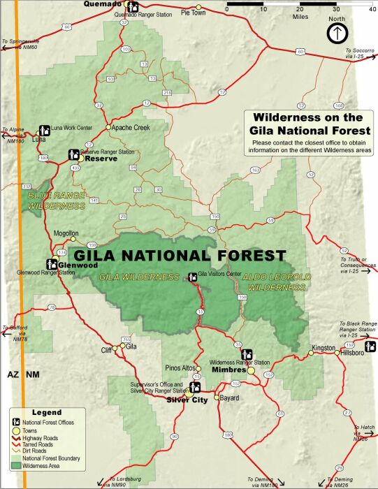
| Description |
Map of the Gila National Forest (light green), with designated wilderness areas (dark green) — located in southwestern New Mexico.
|
|||
| Source | US Forest Service[1] | |||
| Author | USFS | |||
| Permission (Reusing this file) |
|
File history
Click on a date/time to view the file as it appeared at that time.
| Date/Time | Thumbnail | Dimensions | User | Comment | |
|---|---|---|---|---|---|
| current | 02:01, 31 March 2008 | | 541 × 700 (83 KB) | Axcordion~commonswiki | {{Information |Description=Map of designated wilderness areas in Arizona's Gila National Forest. |Source=US Forest Service[http://www2.srs.fs.fed.us/r3/gila/recreation/recmap.asp?activity=wild] |Date= |Author=USFS |Permission={{PD-USGov-USDA-FS}} |other_v |
File usage
The following pages on the English Wikipedia use this file (pages on other projects are not listed):
Global file usage
The following other wikis use this file:
- Usage on de.wikipedia.org
- Usage on es.wikipedia.org
- Usage on fa.wikipedia.org
- Usage on fr.wikipedia.org