
File:Goblu beatosu.jpg
Goblu_beatosu.jpg (410 × 230 pixels, file size: 73 KB, MIME type: image/jpeg)
Summary[edit]
| Description |
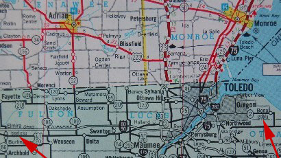
1978–79 State of Michigan map showing Goblu and Beatosu, OH |
|---|---|
| Source |
Created by Michigan Department of Transportation, as displayed at Garrett, Bob (October 31, 2008). "Beatosu and Goblu, Ohio". Archives Image of the Month. Archives of Michigan, Michigan Historical Center, Michigan Department of Natural Resources. Retrieved August 9, 2009. |
| Article | |
| Portion used |
Sections N11–N13 of the main state map |
| Low resolution? |
Yes |
| Purpose of use |
The map serves to illustrate the location and existence of these fictitious towns, verifying for the reader that the map really does depict them. |
| Replaceable? |
No, the fictitious towns were only listed on a limited number of the maps printed in 1978. Subsequent reprintings for 1979 omitted the towns |
| Fair useFair use of copyrighted material in the context of Beatosu and Goblu//en.wikipedia.org/wiki/File:Goblu_beatosu.jpgtrue | |
Licensing:[edit]
 | This image is a faithful digitisation of a unique historic image, and the copyright for it is most likely held by the person who created the image or the agency employing the person. It is believed that the use of this image may qualify as non-free use under the Copyright law of the United States. Any other uses of this image, on Wikipedia or elsewhere, may be copyright infringement. See Wikipedia:Non-free content for more information. Please remember that the non-free content criteria require that non-free images on Wikipedia must not "[be] used in a manner that is likely to replace the original market role of the original copyrighted media." Use of historic images from press agencies must only be of a transformative nature, when the image itself is the subject of commentary rather than the event it depicts (which is the original market role, and is not allowed per policy). |
| If this tag does not accurately describe this image, please replace it with an appropriate one. | |
File history
Click on a date/time to view the file as it appeared at that time.
| Date/Time | Thumbnail | Dimensions | User | Comment | |
|---|---|---|---|---|---|
| current | 22:42, 9 August 2009 | | 410 × 230 (73 KB) | RMc (talk | contribs) | {{Information |Description = Portion of 1978 State of Michigan map |Source = Michigan.gov |Date = 2009 |Author = State of Michigan archivist |Permission = |other_versions = }} |
You cannot overwrite this file.