
File:Goode-homolosine.jpg

Size of this preview: 800 × 400 pixels. Other resolutions: 320 × 160 pixels | 640 × 320 pixels | 1,024 × 512 pixels | 1,280 × 640 pixels | 2,048 × 1,024 pixels.
Original file (2,048 × 1,024 pixels, file size: 425 KB, MIME type: image/jpeg)
| This is a file from the Wikimedia Commons. Information from its description page there is shown below. Commons is a freely licensed media file repository. You can help. |
Summary
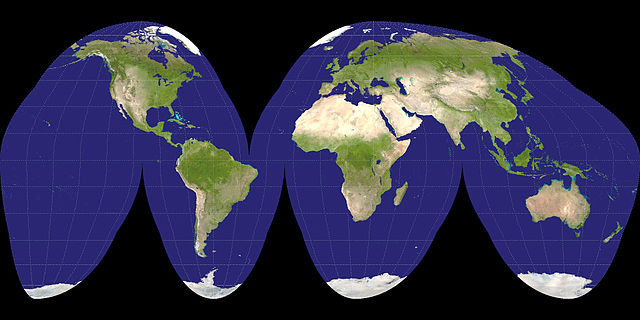
| Description | A Goode projection of a Visible Earth image collected by the Earth Observatory experiment of the U.S. Government's NASA space agency. The reticle is 15 degrees in latitude and longitude. | ||
| Date | 26 October 2005 (according to Exif data) | ||
| Source |
NASA
|
||
| Author | NASA |

| This file is in the public domain in the United States because it was solely created by NASA. NASA copyright policy states that "NASA material is not protected by copyright unless noted". (See Template:PD-USGov, NASA copyright policy page or JPL Image Use Policy.) | ||
 |
Warnings:
|
File history
Click on a date/time to view the file as it appeared at that time.
| Date/Time | Thumbnail | Dimensions | User | Comment | |
|---|---|---|---|---|---|
| current | 21:44, 3 December 2006 | | 2,048 × 1,024 (425 KB) | Electionworld | {{ew|en|mdf}} A Goode projection of a {{link|Visible Earth}} image collected by the {{link|Earth Observatory}} experiment of the U.S. Government's {{link|NASA}} space agency. The reticle is 15 degrees in latitude and longitude. {{PD-self}} [[Category:Im |
File usage
The following pages on the English Wikipedia use this file (pages on other projects are not listed):
Global file usage
The following other wikis use this file:
- Usage on bn.wikipedia.org
- Usage on he.wikipedia.org