
File:Great Eastern Highway route map.png
Great_Eastern_Highway_route_map.png (600 × 400 pixels, file size: 68 KB, MIME type: image/png)
Summary[edit]
| Description |
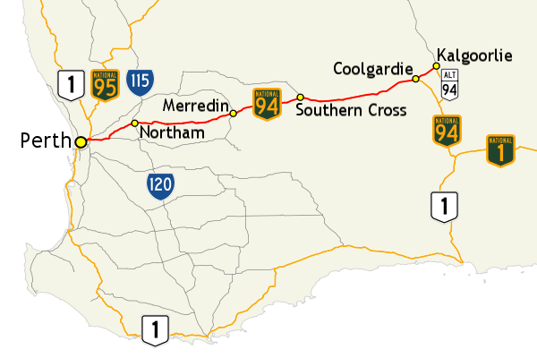
Map of Great Eastern Highway (shown in red) and surrounding road network in south-west Western Australia. |
|---|---|
| Source |
Own work ; |
| Date |
7 July 2013, 21:16:57 |
| Author |
Evad37 © Commonwealth of Australia (Geoscience Australia) 2013. |
| Permission (Reusing this file) |
GIS data: "Save for the content on this website supplied by third parties, the Geoscience Australia logo, the Commonwealth Coat of Arms, and any material protected by a trade mark, Geoscience Australia has applied the Creative Commons Attribution 3.0 Australia licence. Geoscience Australia asserts the right to be recognised as author of the original material in the following manner: © Commonwealth of Australia (Geoscience Australia) 2013." – Copyright - Geoscience Australia |
| Other versions | Alternate version without route markers |
Map created using map data from Geoscience Australia, licensed under the Creative Commons Attribution 3.0 Australia license (CC BY 3.0 AU).
Route markers[edit]
The following route markers are used in this image:
- File:Australian national highway 1.svg
- File:Australian national highway 94.svg
- File:Australian national highway 95.svg
- File:Australian national route 1.svg
- File:Australian national route ALT94.svg
- File:Australian state route 115.svg
- File:Australian state route 120.svg
These images may be covered by copyright in countries other than the United States - the following applies to each image:
| This image is ineligible for copyright and therefore is in the public domain in the United States because it consists entirely of typefaces, individual words, handwriting, slogans, simple geometric shapes, etc. These are not eligible for copyright alone in the United States because they are not original enough or otherwise ineligible (see the Compendium of U.S. Copyright Office Practices (Third Edition), § 313 (pages 67–84)), and thus the image is considered to be in the public domain. See WP:PD#Fonts or Wikipedia:Restricted materials for more information. Please note: The public domain status of this work is only in regards to its copyright status. There may be other intellectual property restrictions protecting this image, such as trademarks or design patents if it is a logo. |
 | Do not copy this file to Wikimedia Commons. This image is believed to be non-free or possibly non-free in its home country. In order for Commons to host a file, it must be free in its home country and in the United States. Some countries, particularly other countries based on common law, have a lower threshold of originality than the United States. |
Licensing[edit]
| This work is licensed under the Creative Commons Attribution-ShareAlike 3.0 License. |
File history
Click on a date/time to view the file as it appeared at that time.
| Date/Time | Thumbnail | Dimensions | User | Comment | |
|---|---|---|---|---|---|
| current | 03:55, 27 January 2014 | | 600 × 400 (68 KB) | Evad37 (talk | contribs) | Reverted to old version: Test made the file size larger with no other apparent difference |
| 03:47, 27 January 2014 |  | 600 × 400 (78 KB) | P. S. Burton (talk | contribs) | test | |
| 07:28, 23 September 2013 |  | 600 × 400 (68 KB) | Evad37 (talk | contribs) | == Summary == {{Information |description=Map of Great Eastern Highway (shown in red) and surrounding road network in south-west Western Australia. |date=7 July 2013, 21:16:57 |source={{own}};<br/> '''GIS data sources:''' Geoscience Australia<br/> '''Ro... |
You cannot overwrite this file.