
File:Great Lakes 1913 Storm Shipwrecks.png

Original file (4,000 × 2,400 pixels, file size: 799 KB, MIME type: image/png)
| This is a file from the Wikimedia Commons. Information from its description page there is shown below. Commons is a freely licensed media file repository. You can help. |
| This image appeared on Wikipedia's Main Page in the Did you know? column on 7 February 2005 (see archives). |
Summary
| Description |
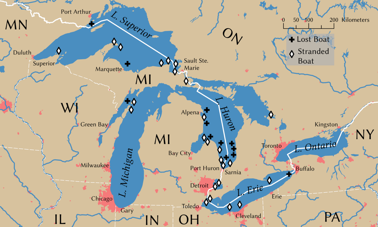
English: Shipwrecks during the Great Lakes Storm of 1913. Wreck locations come from Brown (2002, p. 203) |
||
| Date | |||
| Source | Own work | ||
| Creator | |||
| Credit line | © Tom Fish, geo.fish // Creative Commons BY-SA 4.0 | ||
| Permission (Reusing this file) |
|
||
| Geotemporal data | |||
| Spatial reference system | NAD 1983 Great Lakes Basin Albers [WKID: 31734] | ||
| Scale | 1:11,792,324 | ||
| Archival data | |||
| artwork-references | Brown, David G. (2002) White Hurricane: A Great Lakes November Gale and America's Deadliest Maritime Disaster, International Marine/McGraw-Hill ISBN: 0-07-138037-X. | ||
| PNG development | This map was created with ArcGIS Pro. |
||
Licensing
Data
Rivers, lakes, and urban areas
| This file uses data that was sourced from Natural Earth, a public domain dataset. From the terms of use:
All versions of Natural Earth raster + vector map data found on this website are in the public domain. You may use the maps in any manner, including modifying the content and design, electronic dissemination, and offset printing. The primary authors, Tom Patterson and Nathaniel Vaughn Kelso, and all other contributors renounce all financial claim to the maps and invites you to use them for personal, educational, and commercial purposes. |
Shipwreck locations
The locations of the shipwrecks are facts and are not eligible for copyright protection
| This work is ineligible for copyright and therefore in the public domain because it consists entirely of information that is common property and contains no original authorship. |
International boundary
The international boundaries are sourced from the Large Scale International Boundaries published by the US Department of State
| This image is a work of a United States Department of State employee, taken or made as part of that person's official duties. As a work of the U.S. federal government, the image is in the public domain per 17 U.S.C. § 101 and § 105 and the Department Copyright Information. |  |
State boundary
The state boundaries are sourced from STATE_BOUNDS the United States Geological Survey
This image is in the public domain in the United States because it only contains materials that originally came from the United States Geological Survey, an agency of the United States Department of the Interior. For more information, see the official USGS copyright policy.
|
Final Map
- You are free:
- to share – to copy, distribute and transmit the work
- to remix – to adapt the work
- Under the following conditions:
- attribution – You must give appropriate credit, provide a link to the license, and indicate if changes were made. You may do so in any reasonable manner, but not in any way that suggests the licensor endorses you or your use.
- share alike – If you remix, transform, or build upon the material, you must distribute your contributions under the same or compatible license as the original.
File history
Click on a date/time to view the file as it appeared at that time.
| Date/Time | Thumbnail | Dimensions | User | Comment | |
|---|---|---|---|---|---|
| current | 23:54, 8 November 2021 | | 4,000 × 2,400 (799 KB) | Guerillero | Remedy copyright issues |
| 19:07, 27 February 2007 |  | 1,786 × 1,194 (1.05 MB) | SalomonCeb | Shipwrecks during the en:Great Lakes Storm of 1913. Reference: ''White Hurricane'', by David G. Brown, 2002. All text and icons were added to the PD blank map located at: http://walrus.wr.usgs.gov/infobank/gazette/jpg/regions/fr_glez.jpg {{PD-s |
File usage
Global file usage
The following other wikis use this file:
- Usage on ca.wikipedia.org
- Usage on de.wikipedia.org
- Usage on de.wiktionary.org
- Usage on fr.wikipedia.org
- Usage on nl.wikipedia.org
- Usage on ru.wikipedia.org
- Usage on uz.wikipedia.org