
File:Haapsalu Region in 1705.png
No higher resolution available.
Haapsalu_Region_in_1705.png (676 × 416 pixels, file size: 502 KB, MIME type: image/png)
| This is a file from the Wikimedia Commons. Information from its description page there is shown below. Commons is a freely licensed media file repository. You can help. |
Summary
| Description |
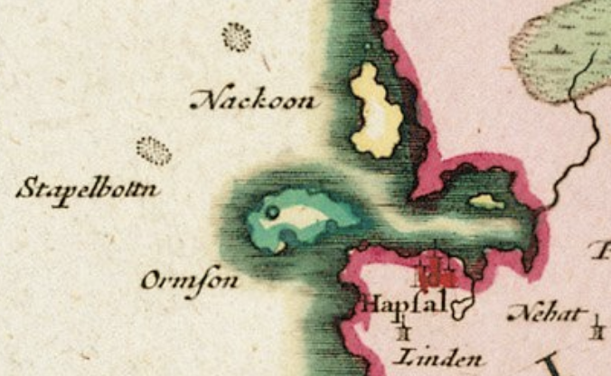
English: This is a section of the Ducatuum Livoniæ et Curlandiæ Nova Tabula map by Pieter Mortier, showing Ormſon/Ormson island (Vormsi island today), Nackoon island (Noarootsi Peninsula today, as it joined with the mainland in the middle of the 19th century), Hapſal/Hapsal (Haapsalu today), Linden castle (Ungru Castle ruins today), and Nehat (Nikha today). I could not find reference to Stapelbottn shoal outside of https://www.google.com/books/edition/Eibofolke_oder_die_Schweden_an_den_K%C3%BCst/04Hi5iOKMbQC?hl=en&gbpv=1&dq=stapelbottn&pg=PT3&printsec=frontcover, which is in German. |
| Date | |
| Source | https://www.nlib.ee/html/digi/maps/mliiv18-eng.html or https://commons.wikimedia.org/wiki/File:1706_Livoni%C3%A6_de_Wit-_Mortier.jpg |
| Author | Wit, F de; Mortier, Pieter |
| Camera location | | View this and other nearby images on: OpenStreetMap |
|---|
Licensing
| This file is made available under the Creative Commons CC0 1.0 Universal Public Domain Dedication. | |
| The person who associated a work with this deed has dedicated the work to the public domain by waiving all of their rights to the work worldwide under copyright law, including all related and neighboring rights, to the extent allowed by law. You can copy, modify, distribute and perform the work, even for commercial purposes, all without asking permission.
|
File history
Click on a date/time to view the file as it appeared at that time.
| Date/Time | Thumbnail | Dimensions | User | Comment | |
|---|---|---|---|---|---|
| current | 21:46, 25 May 2021 | | 676 × 416 (502 KB) | Historical Cartograph | Uploaded a work by Wit, F de; Mortier, Pieter from https://www.nlib.ee/html/digi/maps/mliiv18-eng.html or https://commons.wikimedia.org/wiki/File:1706_Livoni%C3%A6_de_Wit-_Mortier.jpg with UploadWizard |
File usage
The following pages on the English Wikipedia use this file (pages on other projects are not listed):