
File:Hamersley location.jpg
No higher resolution available.
Hamersley_location.jpg (353 × 472 pixels, file size: 54 KB, MIME type: image/jpeg)
| This is a file from the Wikimedia Commons. Information from its description page there is shown below. Commons is a freely licensed media file repository. You can help. |
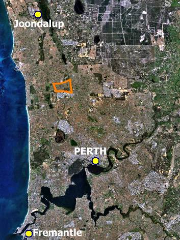
| Description | Northern suburbs of Perth, Western Australia from space, with the suburb of Hamersley marked in orange, and city centres marked for reference. |
| Date | |
| Source | Created by Hesperian using NASA World Wind |
| Author | Orderinchaos78 |
| Permission (Reusing this file) |
public domain data; if there is any intellectual property in the fill, I release that into the public domain too. |
| Other versions | Image:Northern suburbs of Perth.png |
| This image is in the public domain because it is a screenshot from NASA’s globe software World Wind using a public domain layer, such as Blue Marble, MODIS, Landsat, SRTM, USGS or GLOBE.
|
 |
File history
Click on a date/time to view the file as it appeared at that time.
| Date/Time | Thumbnail | Dimensions | User | Comment | |
|---|---|---|---|---|---|
| current | 14:16, 24 February 2007 | | 353 × 472 (54 KB) | Orderinchaos | {{Information |Description=Northern suburbs of Perth, Western Australia from space, with the suburb of Hamersley marked in orange, and city centres marked for reference. |Source=Created by Hesperian using NASA World Wind |Date=2007-01-0 |
File usage
The following pages on the English Wikipedia use this file (pages on other projects are not listed):