
File:Helsinki tram map planned 2010-2025.png

Size of this preview: 800 × 595 pixels. Other resolutions: 320 × 238 pixels | 640 × 476 pixels | 1,024 × 762 pixels | 1,280 × 952 pixels | 1,869 × 1,390 pixels.
Original file (1,869 × 1,390 pixels, file size: 127 KB, MIME type: image/png)
| This is a file from the Wikimedia Commons. Information from its description page there is shown below. Commons is a freely licensed media file repository. You can help. |
Summary
| Description |
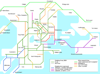
English: A map of expansions to the Helsinki tram network planned to be built 2010 onwards. The decision to be built has been made for some new lines (Jätkäsaari, Ilmala, Laajasalo), others are pending approval by the city council (Kalasatama, Jokeri) while the rest are proposed expansions that might not be built. Place names in Finnish, map key in English. Versions in other languages can be made on request.
Suomi: Kartta Helsingin raitiovaunulinjaston suunnitelluista laajennuksista 2010 eteenpäin. Jätkäsaaren, Ilmalan ja Laajasalon linjoista on tehty rakennuspäätös. Kalasataman ja Jokerin rakentaminen odottaa kaupunginvaltuuston hyväksyntää. Muut esitetyt laajennukset ovat eri yhteyksissä tehtyjä ehdotuksia joiden toteutuminen ei ole varmaa. Kartassa suomenkielinen nimistö, mutta merkkien selitykset englanniksi; muukielisiä versiota voidaan tehdä pyydettäessä. |
| Date | |
| Source | Own work |
| Author | Kalle Id |

|
This map image could be re-created using vector graphics as an SVG file. This has several advantages; see Commons:Media for cleanup for more information. If an SVG form of this image is available, please upload it and afterwards replace this template with
{{vector version available|new image name}}.
It is recommended to name the SVG file “Helsinki tram map planned 2010-2025.svg”—then the template Vector version available (or Vva) does not need the new image name parameter. |
Licensing
I, the copyright holder of this work, hereby publish it under the following license:
This file is licensed under the Creative Commons Attribution-Share Alike 3.0 Unported license.
- You are free:
- to share – to copy, distribute and transmit the work
- to remix – to adapt the work
- Under the following conditions:
- attribution – You must give appropriate credit, provide a link to the license, and indicate if changes were made. You may do so in any reasonable manner, but not in any way that suggests the licensor endorses you or your use.
- share alike – If you remix, transform, or build upon the material, you must distribute your contributions under the same or compatible license as the original.
|
|
This transport map image could be re-created using vector graphics as an SVG file. This has several advantages; see Commons:Media for cleanup for more information. If an SVG form of this image is available, please upload it and afterwards replace this template with
{{vector version available|new image name}}.
It is recommended to name the SVG file “Helsinki tram map planned 2010-2025.svg”—then the template Vector version available (or Vva) does not need the new image name parameter. |
File history
Click on a date/time to view the file as it appeared at that time.
| Date/Time | Thumbnail | Dimensions | User | Comment | |
|---|---|---|---|---|---|
| current | 17:20, 3 April 2009 | | 1,869 × 1,390 (127 KB) | Kjet | Updated following the decision on a study about a potantial line to Otaniemi. |
| 11:40, 20 February 2009 |  | 1,869 × 1,390 (121 KB) | Kjet | Minor change to bring the shape of the existing network in line with the other maps. | |
| 11:39, 14 December 2008 |  | 1,869 × 1,390 (121 KB) | Kjet | Updated according to the most recent (& likely to be realised) plan for Jätkäsaari & Munkkisaari lines. | |
| 12:35, 13 November 2008 |  | 1,869 × 1,390 (121 KB) | Kjet | Updated following the approval of the extension into Laajasalo and a new proposal. also simplified the colour coding slightly. | |
| 08:56, 19 October 2008 |  | 1,869 × 1,390 (119 KB) | Kjet | Updated version. | |
| 16:21, 4 October 2008 |  | 1,869 × 1,390 (118 KB) | Kjet | Improved geographical accuracy, correct information on which lines are decided to be built, correct official proposed route for Kalasatama-Hakaniemi tracks, Haltia-holberg's line 1 rerouting/extension proposal (under Other 2008 proposals), and Rail-Joker | |
| 06:39, 18 August 2008 |  | 1,869 × 1,390 (111 KB) | Kjet | New version incliding the likely-to-be-built north- and southwards expansions of line 9. | |
| 15:04, 24 July 2008 |  | 1,869 × 1,390 (108 KB) | Kjet | {{Information |Description= |Source= |Date= |Author= |Permission= |other_versions= }} | |
| 14:53, 24 July 2008 |  | 1,869 × 1,390 (108 KB) | Kjet | {{Information |Description={{en|1=A map of expansions to the Helsinki tram network planned to be built 2010 onwards. The decision to be built has been made for some new lines (Jätkäsaari, Laajasalo), others are proposed expansions that might or might no |
File usage
The following pages on the English Wikipedia use this file (pages on other projects are not listed):
Global file usage
The following other wikis use this file:
- Usage on fi.wikipedia.org
- Usage on fr.wikipedia.org
- Usage on sv.wikipedia.org
- Usage on uk.wikipedia.org