
File:Hillfield House, Gloucester (geograph 3833102).jpg
Size of this preview: 624 × 599 pixels. Other resolutions: 250 × 240 pixels | 500 × 480 pixels | 652 × 626 pixels.
Original file (652 × 626 pixels, file size: 344 KB, MIME type: image/jpeg)
| This is a file from the Wikimedia Commons. Information from its description page there is shown below. Commons is a freely licensed media file repository. You can help. |
.jpg)
| This image appeared on Wikipedia's Main Page in the Did you know? column on 15 May 2019 (see archives). |
Summary
| Description |
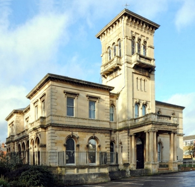
English: Hillfield House, Gloucester Hillfield House is now used as a local government office and it stands in its gardens which are now a public park known as Hillfield Gardens. Pevsner describes the house as 'the most elaborate house in Gloucester'. It was built in an Italianate style by John Giles in 1867-9 for the timber merchant Charles Walker. The house is a Grade II listed building. |
| Date | |
| Source | From geograph.org.uk |
| Author | Philip Halling |
| Permission (Reusing this file) |
Creative Commons Attribution Share-alike license 2.0 |
| Attribution (required by the license) | Philip Halling / Hillfield House, Gloucester / |
| Camera location | | View this and other nearby images on: OpenStreetMap |
|---|
.jpg¶ms=051.869800_N_-002.229868_E_globe:Earth_type:camera_source:geograph-osgb36(SO84271905)_heading:315.00&language=en)
| Object location | | View this and other nearby images on: OpenStreetMap |
|---|
.jpg¶ms=051.869890_N_-002.230010_E_globe:Earth_class:object_type:object_source:geograph-osgb36(SO84261906)_heading:315.00&language=en)
Licensing

|
This image was taken from the Geograph project collection. See this photograph's page on the Geograph website for the photographer's contact details. The copyright on this image is owned by Philip Halling and is licensed for reuse under the Creative Commons Attribution-ShareAlike 2.0 license.
|
This file is licensed under the Creative Commons Attribution-Share Alike 2.0 Generic license.
Attribution: Philip Halling
- You are free:
- to share – to copy, distribute and transmit the work
- to remix – to adapt the work
- Under the following conditions:
- attribution – You must give appropriate credit, provide a link to the license, and indicate if changes were made. You may do so in any reasonable manner, but not in any way that suggests the licensor endorses you or your use.
- share alike – If you remix, transform, or build upon the material, you must distribute your contributions under the same or compatible license as the original.
File history
Click on a date/time to view the file as it appeared at that time.
| Date/Time | Thumbnail | Dimensions | User | Comment | |
|---|---|---|---|---|---|
| current | 13:53, 10 April 2019 | | 652 × 626 (344 KB) | Philafrenzy | crop |
| 13:50, 10 April 2019 |  | 700 × 634 (398 KB) | Philafrenzy | crop | |
| 20:16, 13 October 2018 |  | 1,024 × 680 (216 KB) | Tyssil | Transferred from geograph.co.uk using [https://tools.wmflabs.org/geograph2commons/ geograph2commons] |
File usage
The following pages on the English Wikipedia use this file (pages on other projects are not listed):
Global file usage
The following other wikis use this file:
- Usage on sv.wikipedia.org
.jpg&oldid=897130599)