
File:Holy Roman Empire c. 1700.png
Size of this preview: 800 × 497 pixels. Other resolutions: 320 × 199 pixels | 640 × 398 pixels | 1,024 × 636 pixels | 1,281 × 796 pixels.
Original file (1,281 × 796 pixels, file size: 635 KB, MIME type: image/png)
| This is a file from the Wikimedia Commons. Information from its description page there is shown below. Commons is a freely licensed media file repository. You can help. |
Summary
| Description |
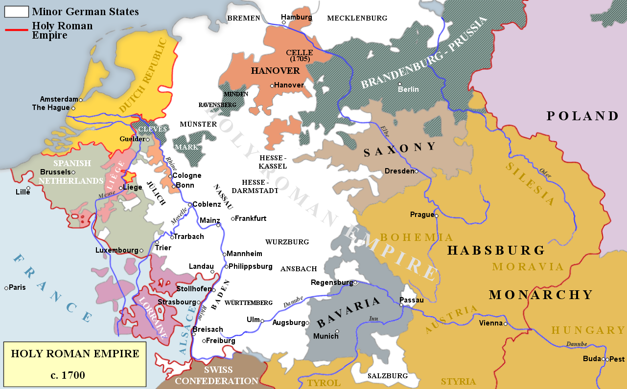
English: Map of states and territories within the Holy Roman Empire in around 1700
Hanover (House of Welf)
Brandenburg-Prussia (House of Hohenzollern)
Saxony (House of Wettin)
Bavaria (House of Wittelsbach)
Austria (House of Habsburg) |
| Date | |
| Source | Own work |
| Author | Rebel Redcoat |
Licensing
I, the copyright holder of this work, hereby publish it under the following license:
This file is licensed under the Creative Commons Attribution-Share Alike 3.0 Unported license.
- You are free:
- to share – to copy, distribute and transmit the work
- to remix – to adapt the work
- Under the following conditions:
- attribution – You must give appropriate credit, provide a link to the license, and indicate if changes were made. You may do so in any reasonable manner, but not in any way that suggests the licensor endorses you or your use.
- share alike – If you remix, transform, or build upon the material, you must distribute your contributions under the same or compatible license as the original.
File history
Click on a date/time to view the file as it appeared at that time.
| Date/Time | Thumbnail | Dimensions | User | Comment | |
|---|---|---|---|---|---|
| current | 16:41, 15 January 2014 | | 1,281 × 796 (635 KB) | Rebel Redcoat~commonswiki | additions/improvements |
| 17:47, 6 January 2014 |  | 1,336 × 831 (463 KB) | Rebel Redcoat~commonswiki | User created page with UploadWizard |
File usage
The following pages on the English Wikipedia use this file (pages on other projects are not listed):
Global file usage
The following other wikis use this file:
- Usage on fi.wikipedia.org
- Usage on ga.wikipedia.org
- Usage on he.wikipedia.org
- Usage on it.wikipedia.org
- Usage on pl.wikipedia.org
- Usage on zh.wikipedia.org