
File:Indian Timothy Bridge.jpg

Size of this preview: 800 × 561 pixels. Other resolutions: 320 × 224 pixels | 640 × 449 pixels | 1,024 × 718 pixels | 1,280 × 898 pixels | 2,560 × 1,796 pixels | 4,636 × 3,252 pixels.
Original file (4,636 × 3,252 pixels, file size: 1.66 MB, MIME type: image/jpeg)
| This is a file from the Wikimedia Commons. Information from its description page there is shown below. Commons is a freely licensed media file repository. You can help. |

|
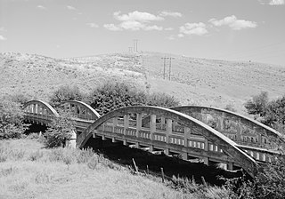
This image is a JPEG version of the original TIF image at File: PERSPECTIVE OF DOUBLE ARCHES LOOKING 40 DEGREES EAST - Indian Timothy Memorial Bridge, U.S. Route 12 spanning Alpowa Creek, Silcott, Asotin County, WA HAER WASH,2-SILC.V,1-2.tif.
However, any edits to the image should be based on the original TIF version in order to prevent generation loss, and both versions should be updated. Do not make edits based on this version. |
Summary
| Description |
English: The Indian Timothy Bridge near Silcott, Asotin County, Washington.
|
|||||||||||||||||||||||
| Date | ||||||||||||||||||||||||
| Source |
Library of Congress, Prints and Photograph Division - Historic American Engineering Record Call number: WASH,2-SILC.V,1-2
|
|||||||||||||||||||||||
| Author |
|
|||||||||||||||||||||||

.jpg)
| Object location | | View this and other nearby images on: OpenStreetMap |
|---|
Licensing
| This image or media file contains material based on a work of a National Park Service employee, created as part of that person's official duties. As a work of the U.S. federal government, such work is in the public domain in the United States. See the NPS website and NPS copyright policy for more information. |
|
File history
Click on a date/time to view the file as it appeared at that time.
| Date/Time | Thumbnail | Dimensions | User | Comment | |
|---|---|---|---|---|---|
| current | 03:50, 16 March 2009 | | 4,636 × 3,252 (1.66 MB) | Martin H. | High res; cropped |
| 22:49, 24 October 2008 |  | 588 × 411 (44 KB) | Cropbot | upload cropped version, operated by User:Finavon. Summary: border cropped | |
| 06:19, 8 September 2008 |  | 640 × 455 (50 KB) | Murderbike~commonswiki | {{Information |Description={{en|1=The Indian Timothy Bridge near Silcott, Washington.}} |Source=http://memory.loc.gov/cgi-bin/displayPhoto.pl?path=/pnp/habshaer/wa/wa0400/wa0426/photos&topImages=370326pr.jpg&topLinks=370326pv.jpg,370326pu.tif&title=2.%20% |
File usage
The following pages on the English Wikipedia use this file (pages on other projects are not listed):
Global file usage
The following other wikis use this file:
- Usage on de.wikipedia.org
- Usage on www.wikidata.org