
File:Kašperské Hory od Liščího vrchu.jpg

Size of this preview: 800 × 533 pixels. Other resolutions: 320 × 213 pixels | 640 × 427 pixels | 1,024 × 683 pixels | 1,280 × 853 pixels | 2,560 × 1,707 pixels | 3,504 × 2,336 pixels.
Original file (3,504 × 2,336 pixels, file size: 3.25 MB, MIME type: image/jpeg)
| This is a file from the Wikimedia Commons. Information from its description page there is shown below. Commons is a freely licensed media file repository. You can help. |
|
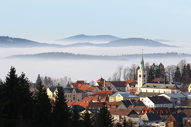
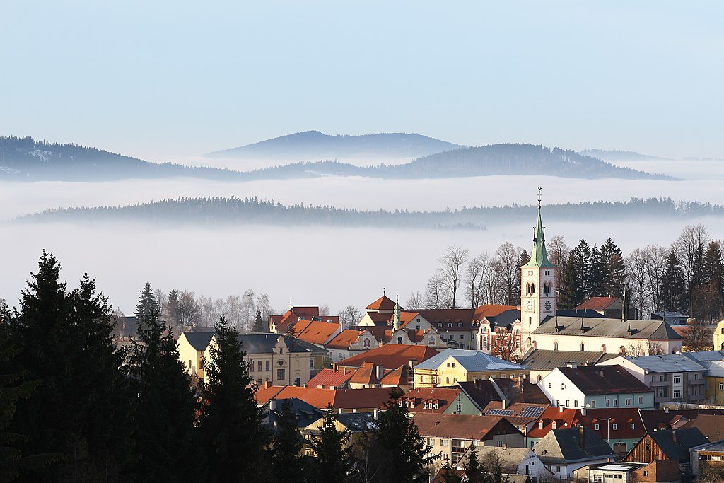
This image was selected as picture of the day on Wikimedia Commons for 17 August 2008. It was captioned as follows: English: Town of Kašperské Hory with St Margaret church as seen from the Liščí vrch (794 m). Other languages:
Asturianu: Vista de la ciudá de Kašperské Hory cola ilesia de Santa Margarita adicada dende'l monte Liščí vrch (794 m), República Checa. Čeština: Kašperské Hory s dominantou kostela svaté Markéty v pohledu od Liščího vrchu Dansk: Byen Kašperské Hory i Tjekkiet, set froa Liščí vrch-højdedraget (794 m). Deutsch: Blick über die tschechische Stadt Kašperské Hory (Bergreichenstein) vom 794 m hohen Liščí vrch aus. English: Town of Kašperské Hory with St Margaret church as seen from the Liščí vrch (794 m). Español: Vista de la ciudad de Kašperské Hory con la iglesia de Santa Margarita vista desde el monte Liščí vrch (794 m), República Checa. Français : La bourgade de Kašperské Hory (République tchèque) et son église Sainte Marguerite vues du mont Liščí vrch (794 m). Italiano: Il paese di Kašperské Hory visto dal monte Liščí vrch nella Regione di Plzeň, Repubblica Ceca. Magyar: A csehországi Kašperské Hory látképe a Szent Margit-templommal a 794 méter magas Liščí vrch magaslatról Nederlands: gezicht op de Tsjechische stad Kašperské Hory met de Margarethakerk, gezien vanaf de berg Liščí vrch (794 meter) Polski: Czeskie miasto Kašperské Hory widziane ze wzgórza o nazwie Liščí vrch (794 m). Português: Cidade de Kašperské Hory com a igreja de Santa Margarida vista do monte Liščí vrch (794 m), localizada em Plzeň na República Checa. Română: Vedere de pe muntele Liščí vrch (794 m) asupra orașului ceh Kašperské Hory. Беларуская: Чэшскі горад Кашперске-Горы і царква Св. Маргарыты. 한국어: 체코의 카쉬퍼스케 호리. 성 마그넷 교회가 보인다. 日本語: Liščí vrch(794m)から見たKašperské Horyの街とセント・マーガレット教会 中文: 捷克共和国比尔森州卡什佩尔斯凯霍里风景,尖顶的建筑为圣玛格丽特教堂 العربية : مدينة Kašperské Hory مع كنيسة سانت مارجريت بجمهورية التشيك كما ترى من Liščí vrch (794 m). |
| Description |
English: Town of Kašperské Hory with St Margaret church as seen from the Liščí vrch (794 m).
Français : La bourgade de Kašperské Hory et son église Sainte Marguerite vues du mont Liščí vrch (794 m). |
||
| Date | |||
| Source |
Čeština: digitální fotografie |
||
| Author | Adam Hauner | ||
| Permission (Reusing this file) |
I, the copyright holder of this work, hereby publish it under the following licenses:
This file is licensed under the Creative Commons Attribution 3.0 Unported license.
You may select the license of your choice. |

| Camera location | | View this and other nearby images on: OpenStreetMap |
|---|
File history
Click on a date/time to view the file as it appeared at that time.
| Date/Time | Thumbnail | Dimensions | User | Comment | |
|---|---|---|---|---|---|
| current | 17:25, 20 January 2008 | | 3,504 × 2,336 (3.25 MB) | Adam Hauner | {{Information |Description={{cs|Kašperské Hory s dominantou kostela svaté Markéty v pohledu od Liščího vrchu.}} |Source={{cs|digitální fotogr |
File usage
The following pages on the English Wikipedia use this file (pages on other projects are not listed):
Global file usage
The following other wikis use this file:
- Usage on af.wikipedia.org
- Usage on ar.wikipedia.org
- Usage on ba.wikipedia.org
- Usage on bn.wikipedia.org
- Usage on ceb.wikipedia.org
- Usage on crh.wikipedia.org
- Usage on cs.wikipedia.org
- Usage on cv.wikipedia.org
- Usage on de.wikipedia.org
- Usage on eo.wikipedia.org
- Usage on es.wikipedia.org
- Usage on et.wikipedia.org
- Usage on eu.wikipedia.org
- Usage on fa.wikipedia.org
- Usage on fr.wikipedia.org
- Usage on hsb.wikipedia.org
- Usage on hu.wikipedia.org
- Usage on ka.wikipedia.org
- Usage on ko.wikipedia.org
- Usage on lbe.wikipedia.org
- Usage on lmo.wikipedia.org
- Usage on ms.wikipedia.org
- Usage on nl.wikipedia.org
- Usage on nl.wikivoyage.org
- Usage on os.wikipedia.org
- Usage on pl.wikipedia.org
- Usage on pt.wikipedia.org
- Usage on ru.wikipedia.org
- Usage on ru.wikinews.org
- Usage on ru.wikivoyage.org
View more global usage of this file.