
File:Karluk voyage map.png

Size of this preview: 800 × 537 pixels. Other resolutions: 320 × 215 pixels | 640 × 429 pixels | 1,002 × 672 pixels.
Original file (1,002 × 672 pixels, file size: 198 KB, MIME type: image/png)
| This is a file from the Wikimedia Commons. Information from its description page there is shown below. Commons is a freely licensed media file repository. You can help. |

|
This map image could be re-created using vector graphics as an SVG file. This has several advantages; see Commons:Media for cleanup for more information. If an SVG form of this image is available, please upload it and afterwards replace this template with
{{vector version available|new image name}}.
It is recommended to name the SVG file “Karluk voyage map.svg”—then the template Vector version available (or Vva) does not need the new image name parameter. |
Summary
| Description |
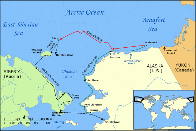
English: Map of the Voyage of the Karluk, including the outbound journey from Nome, the ship's drift in Arctic pack ice, the crew's icy march to Wrangel Island, and Captain Bartlett's journey on foot from Wrangel Island to Emma Harbor in Siberia, and then by ship to St. Michael, Alaska |
| Date | |
| Source |
Own work using:
|
| Author | Finetooth; NormanEinstein |
| Other versions |
Derivative works of this file: |
Licensing
I, the copyright holder of this work, hereby publish it under the following licenses:

|
Permission is granted to copy, distribute and/or modify this document under the terms of the GNU Free Documentation License, Version 1.2 or any later version published by the Free Software Foundation; with no Invariant Sections, no Front-Cover Texts, and no Back-Cover Texts. A copy of the license is included in the section entitled GNU Free Documentation License. |
This file is licensed under the Creative Commons Attribution-Share Alike 3.0 Unported license.
- You are free:
- to share – to copy, distribute and transmit the work
- to remix – to adapt the work
- Under the following conditions:
- attribution – You must give appropriate credit, provide a link to the license, and indicate if changes were made. You may do so in any reasonable manner, but not in any way that suggests the licensor endorses you or your use.
- share alike – If you remix, transform, or build upon the material, you must distribute your contributions under the same or compatible license as the original.
You may select the license of your choice.
File history
Click on a date/time to view the file as it appeared at that time.
| Date/Time | Thumbnail | Dimensions | User | Comment | |
|---|---|---|---|---|---|
| current | 18:36, 30 January 2010 | | 1,002 × 672 (198 KB) | Finetooth | Added black border to left edge. |
| 02:33, 28 January 2010 |  | 1,002 × 672 (198 KB) | Finetooth | Added directional arrow to map scale | |
| 02:12, 28 January 2010 |  | 1,002 × 672 (198 KB) | Finetooth | Added map scale, moved Bering Sea text slightly to reduce clutter | |
| 02:12, 28 January 2010 |  | 1,002 × 672 (198 KB) | Finetooth | Added map scale, moved Bering Sea text slightly to reduce clutter | |
| 18:07, 27 January 2010 |  | 1,002 × 672 (195 KB) | Finetooth | Corrected placement of Port Clarence, moved Arctic Ocean and Beaufort Sea labels to the right and changed font to match East Siberian Sea | |
| 05:42, 27 January 2010 |  | 1,002 × 672 (184 KB) | Finetooth | Cropped, added colour to outward voyage and drift in ice, increased font size of voyage-segment text to improve readability, added Emma Town, Port Hope, Port Clarence, mouth of the Colville River, Herald Island and Herschel Island, made Bartlett's journey | |
| 03:11, 26 January 2010 |  | 1,200 × 672 (312 KB) | Finetooth | {{Information |Description={{en|1=Map of the Voyage of the ''Karluk'', including the outbound journey from Nome, the ship's drift in Arctic pack ice, the crew's icy march to Wrangel Island, and Captain Bartlett's journey on foot from Wrangel Island to Emm |
File usage
The following pages on the English Wikipedia use this file (pages on other projects are not listed):
Global file usage
The following other wikis use this file:
- Usage on fr.wikipedia.org
- Usage on lv.wikipedia.org
- Usage on nl.wikipedia.org
- Usage on pt.wikipedia.org
- Usage on ru.wikipedia.org