
File:Kennack Sands - geograph.org.uk - 999748.jpg
No higher resolution available.
Kennack_Sands_-_geograph.org.uk_-_999748.jpg (640 × 457 pixels, file size: 224 KB, MIME type: image/jpeg)
| This is a file from the Wikimedia Commons. Information from its description page there is shown below. Commons is a freely licensed media file repository. You can help. |
Summary
| Description |
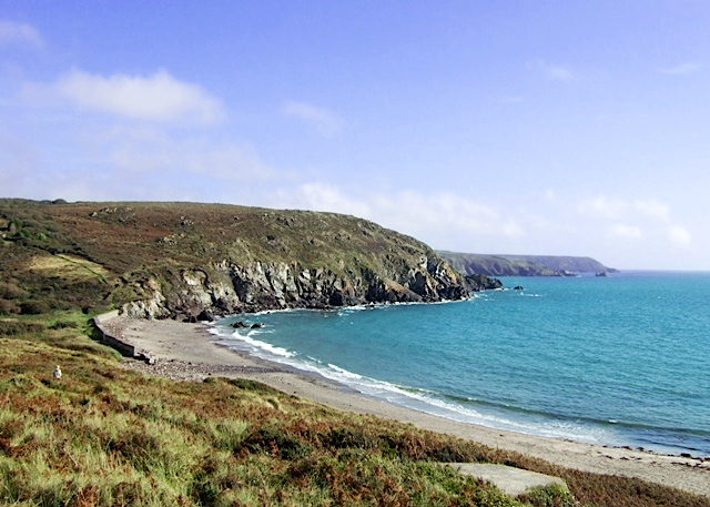
English: Kennack Sands The eastern end of Kennack Sands seen from the little headland that divides the beach. The flat grey object in the foreground is a WW2 pillbox and the seawall at the head of the beach is an old anti-tank defence.
The beach and the area around it is part of the Lizard National Nature Reserve. |
| Date | |
| Source | From geograph.org.uk |
| Author | Simon Huguet |
| Attribution (required by the license) | Simon Huguet / Kennack Sands / |
| Camera location | | View this and other nearby images on: OpenStreetMap |
|---|
_heading:90.00&language=en)
| Object location | | View this and other nearby images on: OpenStreetMap |
|---|
_heading:90.00&language=en)
Licensing

|
This image was taken from the Geograph project collection. See this photograph's page on the Geograph website for the photographer's contact details. The copyright on this image is owned by Simon Huguet and is licensed for reuse under the Creative Commons Attribution-ShareAlike 2.0 license.
|
This file is licensed under the Creative Commons Attribution-Share Alike 2.0 Generic license.
Attribution: Simon Huguet
- You are free:
- to share – to copy, distribute and transmit the work
- to remix – to adapt the work
- Under the following conditions:
- attribution – You must give appropriate credit, provide a link to the license, and indicate if changes were made. You may do so in any reasonable manner, but not in any way that suggests the licensor endorses you or your use.
- share alike – If you remix, transform, or build upon the material, you must distribute your contributions under the same or compatible license as the original.
File history
Click on a date/time to view the file as it appeared at that time.
| Date/Time | Thumbnail | Dimensions | User | Comment | |
|---|---|---|---|---|---|
| current | 22:01, 22 September 2023 | | 640 × 457 (224 KB) | WikiPedant | adjusted levels and colors; sharpened a bit |
| 04:21, 23 February 2011 |  | 640 × 457 (147 KB) | GeographBot | == {{int:filedesc}} == {{Information |description={{en|1=Kennack Sands The eastern end of Kennack Sands seen from the little headland that divides the beach. The flat grey object in the foreground is a WW2 pillbox and the seawall at the head of the beach |
File usage
The following pages on the English Wikipedia use this file (pages on other projects are not listed):
Global file usage
The following other wikis use this file:
- Usage on www.wikidata.org