
File:Kr Heydekrug.png

Size of this preview: 725 × 599 pixels. Other resolutions: 290 × 240 pixels | 581 × 480 pixels | 929 × 768 pixels | 1,027 × 849 pixels.
Original file (1,027 × 849 pixels, file size: 1.96 MB, MIME type: image/png)
| This is a file from the Wikimedia Commons. Information from its description page there is shown below. Commons is a freely licensed media file repository. You can help. |
Summary
| Description |
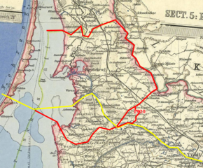
Deutsch: Bearbeiteter Ausschnitt einer Karte von Ostpreußen. Rot: Grenze des Landkreises Heydekrug (1818-1945). Gelb: Heutige Grenze zwischen Litauen (Norden) und Russland (Kaliningrader Gebiet, Süden). Heydekrug heißt auf litauisch Šilutė.
English: Edited detail from a map of East Prussia. Red: Borders of prussian Heydekrug County. Yellow: Modern international border between Lithuania (north) and Russia (Oblast Kaliningrad, south. The lithuanian name for Heydekrug (english: Heath Inn) is Šilutė. |
| Date | |
| Source |
Vogels Karte des Deutschen Reichs (Map of the German Empire). Scale 1:500,000. Perteis, Gotha, 1907. Sheet 5: Königsberg. Author: Carl Vogel (1828-97). Drawn by V.Geyer, H.Kehnert, O.Koffmann, P.Langhans, M.Risch and C.Scherrer. |
| Author | Uploader: Michael König (User:Magadan) → Message. |
Licensing
|
This work is in the public domain in its country of origin and other countries and areas where the copyright term is the author's life plus 70 years or fewer. | |
| This file has been identified as being free of known restrictions under copyright law, including all related and neighboring rights. | |
File history
Click on a date/time to view the file as it appeared at that time.
| Date/Time | Thumbnail | Dimensions | User | Comment | |
|---|---|---|---|---|---|
| current | 22:01, 28 December 2008 | | 1,027 × 849 (1.96 MB) | Magadan | |
| 21:07, 28 December 2008 |  | 1,027 × 849 (1.95 MB) | Magadan | {{Information |Description={{en|1=..}} {{de|1=..}} |Source=Own work |Author=Magadan |Date= |Permission= |other_versions= }} <!--{{ImageUpload|full}}--> |
File usage
The following pages on the English Wikipedia use this file (pages on other projects are not listed):
Global file usage
The following other wikis use this file:
- Usage on be-tarask.wikipedia.org
- Usage on be.wikipedia.org
- Usage on de.wikipedia.org
- Usage on fr.wikipedia.org
- Usage on lt.wikipedia.org
- Usage on lt.wikibooks.org
- Usage on ru.wikipedia.org
- Usage on sl.wikipedia.org
- Usage on uk.wikipedia.org