
File:Lebanon-South Lebanon.png
No higher resolution available.
Lebanon-South_Lebanon.png (150 × 192 pixels, file size: 3 KB, MIME type: image/png)
| This is a file from the Wikimedia Commons. Information from its description page there is shown below. Commons is a freely licensed media file repository. You can help. |
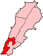
Map of Lebanon showing South Lebanon governorate.
Source: Made by User:Golbez.
This file is licensed under the Creative Commons Attribution 2.0 Generic license.
- You are free:
- to share – to copy, distribute and transmit the work
- to remix – to adapt the work
- Under the following conditions:
- attribution – You must give appropriate credit, provide a link to the license, and indicate if changes were made. You may do so in any reasonable manner, but not in any way that suggests the licensor endorses you or your use.
\
File history
Click on a date/time to view the file as it appeared at that time.
| Date/Time | Thumbnail | Dimensions | User | Comment | |
|---|---|---|---|---|---|
| current | 06:32, 14 July 2005 | | 150 × 192 (3 KB) | Golbez | Map of Lebanon showing South Lebanon governorate. Source: Made by User:Golbez. {{cc-by-2.0}} Category:Maps of Lebanon\ |
File usage
No pages on the English Wikipedia use this file (pages on other projects are not listed).
Global file usage
The following other wikis use this file:
- Usage on ar.wikipedia.org
- محافظة الجنوب (لبنان)
- البازورية
- الناقورة (لبنان)
- زبقين
- دوير (النبطية)
- دير كيفا
- قليا
- الحلوسية
- عيتا الشعب
- العرقوب (لبنان)
- رومين
- كونين
- علما الشعب
- ميفدون
- كفر ملكي
- جزين
- بنت جبيل
- ارزي
- إركي
- البرامية
- برتي
- بقسطة
- بنعفول
- البيسارية
- تفاحتا
- حارة (لبنان)
- خرطوم (صيدا)
- درب (صيدا)
- الدلب (صيدا)
- الزرارية
- زيتا (صيدا)
- السكسكية
- الصالحية (صيدا)
- طنبوريت
- عبرا
- العدوسية
- عين (صيدا)
- الغسانية
- القرية (صيدا)
- قعقعية
- قناريت
- اللوبية
- المعمرية
- مغدوشة
- ملكي (صيدا)
- النجارية
- الهلالية (صيدا)
- عين تينة (البقاع)
- لبايا
- بتدين اللقش
View more global usage of this file.