
File:Location map United Kingdom Reading Central.png

Size of this preview: 562 × 599 pixels. Other resolutions: 225 × 240 pixels | 450 × 480 pixels | 720 × 768 pixels | 1,134 × 1,209 pixels.
Original file (1,134 × 1,209 pixels, file size: 847 KB, MIME type: image/png)
| This is a file from the Wikimedia Commons. Information from its description page there is shown below. Commons is a freely licensed media file repository. You can help. |
Summary
| Description |
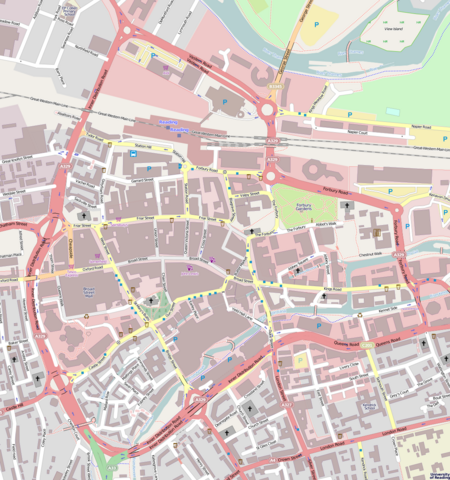
English: Map of Reading Central
Geographic limits:
|
| Date | |
| Source | http://www.openstreetmap.org/?lat=51.45614&lon=-0.97047&zoom=16 |
| Author | OpenStreetMap |
Licensing
This file is licensed under the Creative Commons Attribution-Share Alike 3.0 Unported license.
- You are free:
- to share – to copy, distribute and transmit the work
- to remix – to adapt the work
- Under the following conditions:
- attribution – You must give appropriate credit, provide a link to the license, and indicate if changes were made. You may do so in any reasonable manner, but not in any way that suggests the licensor endorses you or your use.
- share alike – If you remix, transform, or build upon the material, you must distribute your contributions under the same or compatible license as the original.
File history
Click on a date/time to view the file as it appeared at that time.
| Date/Time | Thumbnail | Dimensions | User | Comment | |
|---|---|---|---|---|---|
| current | 23:46, 28 April 2011 | | 1,134 × 1,209 (847 KB) | BaldBoris | =={{int:filedesc}}== {{Information |description={{en|1=Map of Reading Central}} Geographic limits: * N: 51.46258° * S: 51.44969° * W: -0.97991° * E: -0.96103° |date=2011-04-29 |source=http://www.openstreetmap.org/?lat=5 |
File usage
The following pages on the English Wikipedia use this file (pages on other projects are not listed):
- Abbey Gateway, Reading
- Abbey Mill, Reading
- Albion Terrace, Reading
- Broad Street Independent Chapel, Reading
- Forbury Gardens
- Greyfriars Church, Reading
- Hospitium of St John the Baptist
- Inner Distribution Road
- List of monastic houses in Berkshire
- Malmaison Hotel, Reading
- Oracle (workhouse)
- Reading Abbey
- Reading Civic Centre
- Reading Minster
- Reading Museum
- Reading Town Hall
- Roseate Reading Hotel
- St Giles' Church, Reading
- St James's Church, Reading
- St Laurence's Church, Reading
- St Mary's Church, Castle Street, Reading
- Station Hill development, Reading
- The Blade, Reading
- The George Hotel, Reading
- The Hexagon
- Vachel Almshouses
- Watlington House
- User:Tenpop421/sandbox
- Module:Location map/data/United Kingdom Reading Central
- Module:Location map/data/United Kingdom Reading Central/doc
Global file usage
The following other wikis use this file:
- Usage on ar.wikipedia.org
- Usage on ceb.wikipedia.org
- Usage on cy.wikipedia.org
- Usage on fa.wikipedia.org
- Usage on kn.wikipedia.org
- Usage on si.wikipedia.org
- Usage on ta.wikipedia.org
- Usage on te.wikipedia.org
- Usage on tr.wikipedia.org
- Usage on ur.wikipedia.org
- Usage on war.wikipedia.org
- Usage on www.wikidata.org