
File:London1300-marking the spot of the future Marshalsea.png

No higher resolution available.
London1300-marking_the_spot_of_the_future_Marshalsea.png (700 × 536 pixels, file size: 693 KB, MIME type: image/png)
| This is a file from the Wikimedia Commons. Information from its description page there is shown below. Commons is a freely licensed media file repository. You can help. |
Summary
| Description |
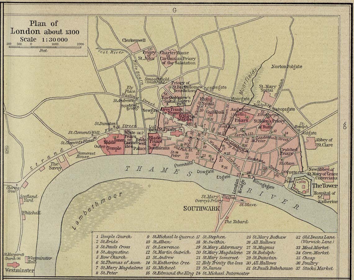
English: Source: Commons Image:London 1300 Historical Atlas William R Shepherd (died 1934).PNG
Description: A map of London in 1300 from a historical atlas by William R Shepherd. Apart from religious foundations and two or three other complexes, the city is confined within its walls, the bulk and heart of the City of London today. The City is flanked to the east and west by the royal fortress of the Tower of London and the royal palace of en:Bridewell. The route from the city to the royal centre of Westminster is not yet fully built up. There is a settlement at en:Southwark, but it is very small. The approximate location of the future Marshalsea prison (first mentioned 1370) is marked in blue. |
| Date | |
| Source | Shepherd, William R. Historical Atlas. New York, Henry Holt and Company, 1923. Direct JPG, Indirect HTML |
| Author | Shepherd, William R. (d. 1934) |
| Permission (Reusing this file) |
This image is in the public domain due to its age. |
.PNG)
Licensing
|
This work is in the public domain in its country of origin and other countries and areas where the copyright term is the author's life plus 70 years or fewer. | |
| This file has been identified as being free of known restrictions under copyright law, including all related and neighboring rights. | |
Original upload log
The original description page was here. All following user names refer to en.wikipedia.
- 2007-12-23 05:07 SlimVirgin 700×536×8 (709283 bytes) {{PD-old}} Source: Commons [[:Image:London 1300 Historical Atlas William R Shepherd (died 1934).PNG]] Description: A map of London in 1300 from a historical atlas by William R Shepherd. Apart from religious foundations and two or three other complexes,
File history
Click on a date/time to view the file as it appeared at that time.
| Date/Time | Thumbnail | Dimensions | User | Comment | |
|---|---|---|---|---|---|
| current | 02:24, 7 June 2008 | | 700 × 536 (693 KB) | File Upload Bot (Magnus Manske) | {{BotMoveToCommons|en.wikipedia}} {{Information |Description={{en|Source: Commons [[:en::Image:London 1300 Historical Atlas William R Shepherd (died 1934).PNG]] Description: A map of London in 1300 from a historical atlas by William R Shepherd. Apart fr |
File usage
No pages on the English Wikipedia use this file (pages on other projects are not listed).
Global file usage
The following other wikis use this file:
- Usage on es.wikipedia.org
- Usage on it.wikipedia.org
- Usage on no.wikipedia.org