
File:Manchester Ship Canal and Salford Quays (geograph 4555343).jpg
No higher resolution available.
Manchester_Ship_Canal_and_Salford_Quays_(geograph_4555343).jpg (640 × 427 pixels, file size: 367 KB, MIME type: image/jpeg)
| This is a file from the Wikimedia Commons. Information from its description page there is shown below. Commons is a freely licensed media file repository. You can help. |
.jpg)
Summary
| Description |
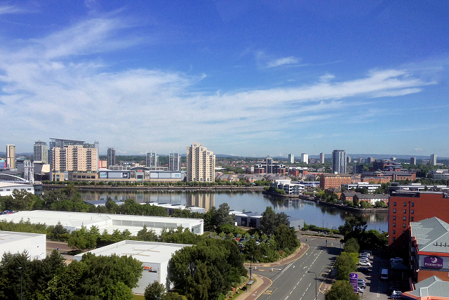
English: A view looking from the rooftop-football pitch at SJ8096 : Hotel Football.
The foreground is part of the Wharfside area of Trafford Park. On the other side of the Manchester Ship Canal is the redeveloped Manchester Docks, now called Salford Quays. |
| Date | |
| Source | From geograph.org.uk |
| Author | David Dixon |
| Permission (Reusing this file) |
Creative Commons Attribution Share-alike license 2.0 |
| Attribution (required by the license) | David Dixon / Manchester Ship Canal and Salford Quays / |
| Camera location | | View this and other nearby images on: OpenStreetMap |
|---|
.jpg¶ms=053.464406_N_-002.289342_E_globe:Earth_type:camera_source:geograph-osgb36(SJ8088896446)_heading:0.00&language=en)
| Object location | | View this and other nearby images on: OpenStreetMap |
|---|
.jpg¶ms=053.468390_N_-002.290390_E_globe:Earth_class:object_type:object_source:geograph-osgb36(SJ80829689)_heading:0.00&language=en)
Licensing

|
This image was taken from the Geograph project collection. See this photograph's page on the Geograph website for the photographer's contact details. The copyright on this image is owned by David Dixon and is licensed for reuse under the Creative Commons Attribution-ShareAlike 2.0 license.
|
This file is licensed under the Creative Commons Attribution-Share Alike 2.0 Generic license.
Attribution: David Dixon
- You are free:
- to share – to copy, distribute and transmit the work
- to remix – to adapt the work
- Under the following conditions:
- attribution – You must give appropriate credit, provide a link to the license, and indicate if changes were made. You may do so in any reasonable manner, but not in any way that suggests the licensor endorses you or your use.
- share alike – If you remix, transform, or build upon the material, you must distribute your contributions under the same or compatible license as the original.
File history
Click on a date/time to view the file as it appeared at that time.
| Date/Time | Thumbnail | Dimensions | User | Comment | |
|---|---|---|---|---|---|
| current | 14:38, 15 February 2023 | | 640 × 427 (367 KB) | Chocolateediter | == {{int:filedesc}} == {{Information |Description={{en|1=A view looking from the rooftop-football pitch at SJ8096 : Hotel Football. The foreground is part of the Wharfside area of Trafford Park. On the other side of the Manchester Ship Canal is the redeveloped Manchester Docks, now called Salford Quays.}} |Source=From [https://www.geograph.org.uk/photo/4555343 geograph.org.uk] |Date=2015-07-03 |Author=[https://www.geograph.org.uk/profile/43729 David Dixon] |Permission=Creative Commons Attri... |
File usage
The following pages on the English Wikipedia use this file (pages on other projects are not listed):
.jpg)