
File:Map Europe 1923-fr.svg

Size of this PNG preview of this SVG file: 800 × 543 pixels. Other resolutions: 320 × 217 pixels | 640 × 434 pixels | 1,024 × 695 pixels | 1,280 × 869 pixels | 2,560 × 1,738 pixels | 1,037 × 704 pixels.
Original file (SVG file, nominally 1,037 × 704 pixels, file size: 228 KB)
| This is a file from the Wikimedia Commons. Information from its description page there is shown below. Commons is a freely licensed media file repository. You can help. |
| Description |
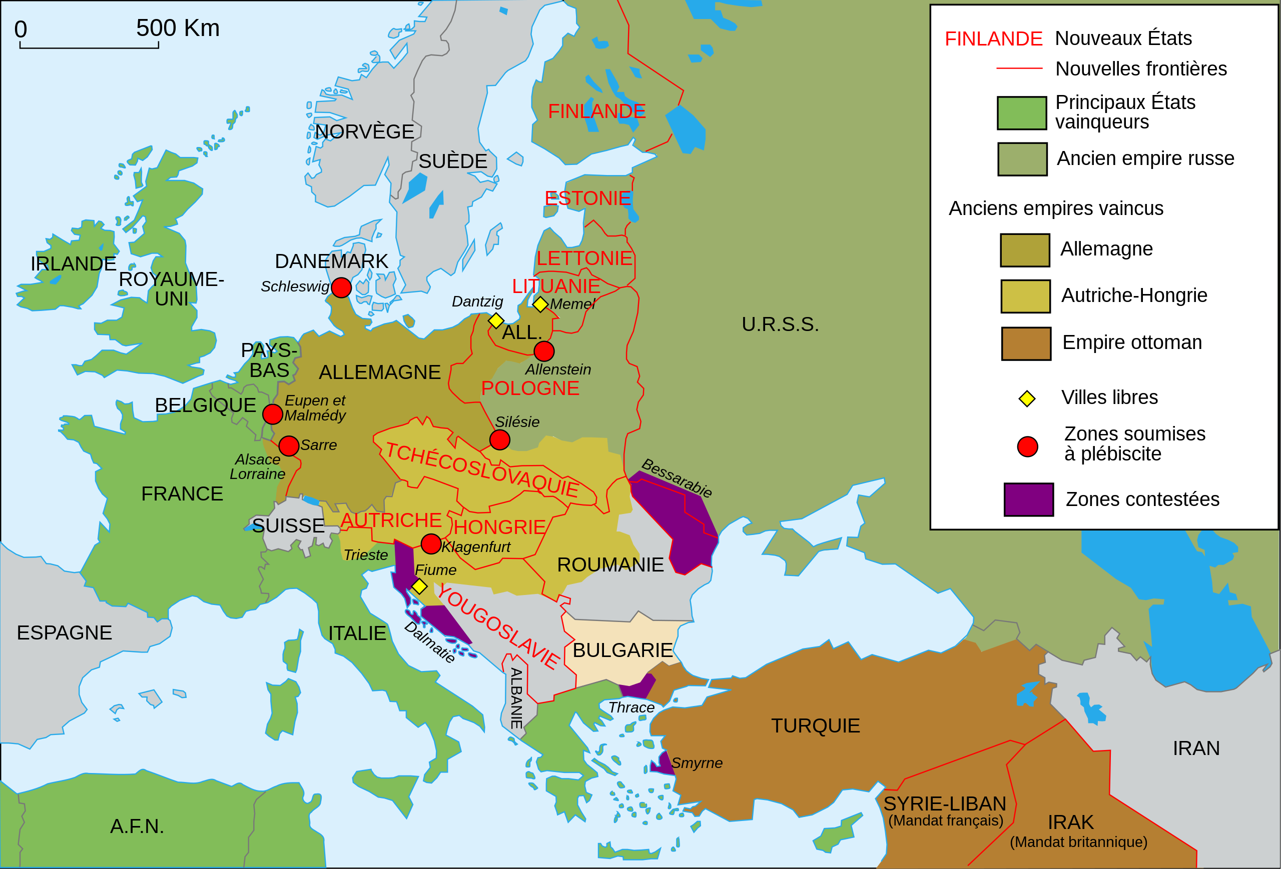
English: Map of Europe in 1923.
Français : Carte de l'Europe en 1923. |
||||||||
| Date | |||||||||
| Source | Own work | ||||||||
| Author | Historicair | ||||||||
| Permission (Reusing this file) |
I, the copyright holder of this work, hereby publish it under the following licenses:
This file is licensed under the Creative Commons Attribution-Share Alike 2.5 Generic, 2.0 Generic and 1.0 Generic license.
You may select the license of your choice. |
||||||||
| Other versions |
[]
|


|
This SVG file contains embedded text that can be translated into your language, using any capable SVG editor, text editor or the SVG Translate tool. For more information see: About translating SVG files. |
File history
Click on a date/time to view the file as it appeared at that time.
| Date/Time | Thumbnail | Dimensions | User | Comment | |
|---|---|---|---|---|---|
| current | 15:52, 29 November 2021 | | 1,037 × 704 (228 KB) | Fierodelveneto | File uploaded using svgtranslate tool (https://svgtranslate.toolforge.org/). Added translation for vec. |
| 22:08, 16 February 2007 |  | 1,037 × 704 (187 KB) | Historicair | ||
| 22:07, 16 February 2007 |  | 1,037 × 704 (187 KB) | Historicair | {{Information |Description={{fr}}Carte de l'Europe en 1923 {{en}}Map of Europe - 1923 |Source=Own work |Date=16/02/2007 |Author=~~~~ |Permission={{self2|GFDL|cc-by-sa-2.5,2.0,1.0}} |other_versions= }} {{Atelier graphique carte}} [[Category:Historical SVG |
File usage
No pages on the English Wikipedia use this file (pages on other projects are not listed).
Global file usage
The following other wikis use this file:
- Usage on fr.wikipedia.org
- Usage on fr.wikiversity.org
- Usage on ro.wikipedia.org
- Usage on vec.wikipedia.org