
File:Map Europe Neighbouring Countries.png
Map_Europe_Neighbouring_Countries.png (450 × 360 pixels, file size: 87 KB, MIME type: image/png)
Summary[edit]
| Description |
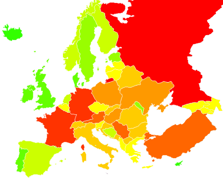
Map of Europe, depicting numbers of neighbouring countries. Red is more neighbouring countries, green is fewer. Except for Russia, Turkey, Azerbaijan, Armenia, Georgia, neighbouring countries outside Europe are not counted. |
|---|---|
| Source |
Original image Image:BlankMap-Europe.png, modified by me. |
| Date |
24 April, 2008 |
| Author | |
| Permission (Reusing this file) |
See below.
|
Licensing:[edit]
| I, the copyright holder of this work, hereby release it into the public domain. This applies worldwide. If this is not legally possible: |
Removed from the following pages:
--OrphanBot (talk) 06:45, 30 April 2008 (UTC)
 | This file is a candidate to be copied to Wikimedia Commons.
Any user may perform this transfer; refer to Wikipedia:Moving files to Commons for details. If this file has problems with attribution, copyright, or is otherwise ineligible for Commons, then remove this tag and DO NOT transfer it; repeat violators may be blocked from editing. Other Instructions
| ||
| |||
File history
Click on a date/time to view the file as it appeared at that time.
| Date/Time | Thumbnail | Dimensions | User | Comment | |
|---|---|---|---|---|---|
| current | 11:16, 29 October 2022 | | 450 × 360 (87 KB) | Рагин1987 (talk | contribs) | Extended map |
| 09:03, 9 August 2008 |  | 450 × 422 (10 KB) | Nikola Smolenski (talk | contribs) | ||
| 05:06, 25 April 2008 |  | 450 × 422 (10 KB) | JIP (talk | contribs) | {{Information |Description=Map of Europe, depicting numbers of neighbouring countries. Red is more neighbouring countries, green is fewer. Except for Russia and Turkey, neighbouring countries outside Europe are not counted. |Source=Original image [[:Image |
You cannot overwrite this file.