File:Map of Angeles Mesa area of Los Angeles, 1916.jpg

Original file (1,152 × 1,478 pixels, file size: 647 KB, MIME type: image/jpeg)
Summary
[edit]| Description |
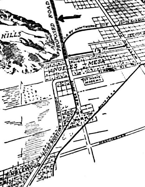
North is at the top of this map from the ‘’Los Angeles Times,’’ August 20, 1916. Angeles Mesa lies horizontally near the center, bounded on the west by Baldwin Hills and on the east by Western Avenue. St. Mary’s Academy is south of it across Slauson Avenue. The “Proposed Road” (signaled by an arrow) and Mesa Drive are now part of Crenshaw Boulevard. The curved horizontal line on the upper right (now Leimert Avenue) marks the Los Angeles Railway Hawthorne line, running on Santa Barbara Avenue (now Martin Luther King Drive) curving into Mesa Drive, continuing to Inglewood, at bottom left. A Santa Fe Railroad track runs northeast-southwest through Hyde Park. Southwest from Mesa Drive lies a paved boulevard (now Florence Avenue) to Redondo Beach. Manchester Avenue (now Boulevard) is at the bottom. |
|---|---|
| Source |
Original publication: Los Angeles Times, August 20, 1916 |
| Date |
August 20, 1916 |
| Author |
Los Angeles Times |
| Permission (Reusing this file) |
See below.
|
Licensing
[edit]| This work is in the public domain in the United States because it was published (or registered with the U.S. Copyright Office) before January 1, 1929. |
File history
Click on a date/time to view the file as it appeared at that time.
| Date/Time | Thumbnail | Dimensions | User | Comment | |
|---|---|---|---|---|---|
| current | 21:39, 26 April 2020 |  | 1,152 × 1,478 (647 KB) | BeenAroundAWhile (talk | contribs) | Uploading an old public-domain work using File Upload Wizard |
You cannot overwrite this file.
File usage
The following 2 pages use this file:
