
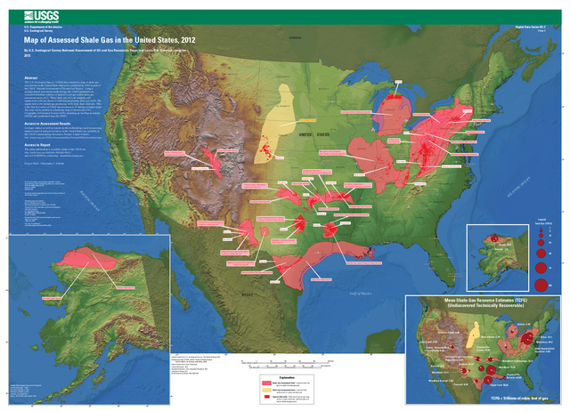
File:Map of Assessed Shale Gas in the United States, 2012.png

Size of this preview: 800 × 578 pixels. Other resolutions: 320 × 231 pixels | 640 × 462 pixels | 1,024 × 740 pixels | 1,280 × 925 pixels | 2,560 × 1,849 pixels | 3,637 × 2,627 pixels.
Original file (3,637 × 2,627 pixels, file size: 12.29 MB, MIME type: image/png)
| This is a file from the Wikimedia Commons. Information from its description page there is shown below. Commons is a freely licensed media file repository. You can help. |
Summary
| Description |
English: Map of Assessed Shale Gas in the United States, 2012 |
| Date | |
| Source | http://pubs.usgs.gov/dds/dds-069/dds-069-z/ |
| Author | USGS |
Licensing
This image is in the public domain in the United States because it only contains materials that originally came from the United States Geological Survey, an agency of the United States Department of the Interior. For more information, see the official USGS copyright policy.
|
File history
Click on a date/time to view the file as it appeared at that time.
| Date/Time | Thumbnail | Dimensions | User | Comment | |
|---|---|---|---|---|---|
| current | 09:01, 24 December 2014 | | 3,637 × 2,627 (12.29 MB) | Anna Frodesiak | full res |
| 01:23, 24 December 2014 |  | 182 × 131 (38 KB) | Anna Frodesiak | User created page with UploadWizard |
File usage
The following pages on the English Wikipedia use this file (pages on other projects are not listed):