
File:Mapa Myotis daubentonii.png

Size of this preview: 800 × 351 pixels. Other resolutions: 320 × 140 pixels | 640 × 281 pixels | 1,425 × 625 pixels.
Original file (1,425 × 625 pixels, file size: 50 KB, MIME type: image/png)
| This is a file from the Wikimedia Commons. Information from its description page there is shown below. Commons is a freely licensed media file repository. You can help. |
Summary
| Description |
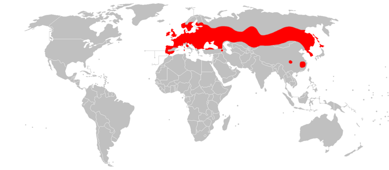
English: Distribution map of Myotis daubentonii.
Español: Mapa de distribución del murciélago de ribera (Myotis daubentonii). |
| Date | |
| Source | Own work |
| Author | Osado |
Data source:IUCN
Licensing
| I, the copyright holder of this work, release this work into the public domain. This applies worldwide. In some countries this may not be legally possible; if so: I grant anyone the right to use this work for any purpose, without any conditions, unless such conditions are required by law. |
File history
Click on a date/time to view the file as it appeared at that time.
| Date/Time | Thumbnail | Dimensions | User | Comment | |
|---|---|---|---|---|---|
| current | 19:40, 21 March 2018 | | 1,425 × 625 (50 KB) | Maphobbyist | South Sudan border |
| 16:13, 10 February 2010 |  | 1,425 × 625 (50 KB) | Osado | {{Information |Description={{en|1=Distribution map of ''Myotis daubentonii''.}} {{es|1=Mapa de distribución del murciélago de ribera (''Myotis daubentonii'').}} |Source={{own}} |Author=Osado |Date=2010 |Permission= |other_versions= }} Dat |
File usage
The following pages on the English Wikipedia use this file (pages on other projects are not listed):
Global file usage
The following other wikis use this file:
- Usage on an.wikipedia.org
- Usage on avk.wikipedia.org
- Usage on be.wikipedia.org
- Usage on bg.wikipedia.org
- Usage on ca.wikipedia.org
- Usage on ceb.wikipedia.org
- Usage on cs.wikipedia.org
- Usage on da.wikipedia.org
- Usage on de.wikipedia.org
- Usage on es.wikipedia.org
- Usage on et.wikipedia.org
- Usage on eu.wikipedia.org
- Usage on fi.wikipedia.org
- Usage on fr.wikipedia.org
- Liste des mammifères en France métropolitaine
- Liste des mammifères en Belgique
- Liste des mammifères en Espagne
- Liste des mammifères en Suisse
- Liste des mammifères au Luxembourg
- Liste des mammifères au Portugal continental
- Liste des mammifères en Italie
- Liste des mammifères en Allemagne
- Liste des mammifères au Royaume-Uni
- Liste des mammifères aux Pays-Bas européens
- Liste des mammifères en Roumanie
- Liste des mammifères en Norvège
- Liste des mammifères en Grèce
- Liste des mammifères en Autriche
- Liste des mammifères en Pologne
- Liste des mammifères en Andorre
- Liste des mammifères au Danemark
- Liste des mammifères en Irlande
- Liste des mammifères en Suède
- Liste des mammifères en Tchéquie
- Liste des mammifères en Finlande
- Liste des mammifères en Croatie
- Liste des mammifères en Hongrie
- Liste des mammifères en Ukraine
- Liste des mammifères à Monaco
View more global usage of this file.