
File:Megalithanlage Sømarkedyssen.jpg

Size of this preview: 800 × 600 pixels. Other resolutions: 320 × 240 pixels | 640 × 480 pixels | 1,024 × 768 pixels | 1,280 × 960 pixels | 2,048 × 1,536 pixels.
Original file (2,048 × 1,536 pixels, file size: 1.19 MB, MIME type: image/jpeg)
| This is a file from the Wikimedia Commons. Information from its description page there is shown below. Commons is a freely licensed media file repository. You can help. |
| Description |
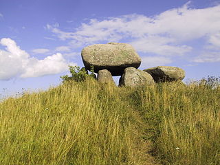
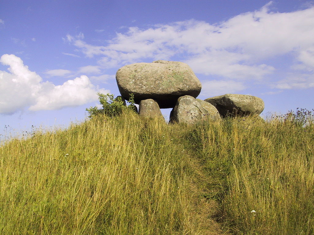
Deutsch: Die bekannteste Megalithanlage Møns: Sømarkedyssen
Dansk: Øst for Sømarke ligger på Stendyssevej Møns bedst kendte stendysse. På en bakketop ligger et fritstående stort dyssekammer med en kort gang. Dyssen er bygget af 7 bæresten og en stor dæksten. Dækstenen er kendt for dens 180 skåltegn fra bronzealderen.
English: The Dolmen "Sømarkedyssen" on Møn, Denmark |
||||||||
| Date | |||||||||
| Source |
Own work (Bera) English: Transferred from de.wikipedia.org. The original description page was here. All following user names refer to de.wikipedia. : 2006-03-30 21:55 . . Bera . . 2048×1536× (1247665 bytes) |
||||||||
| Author | Bera | ||||||||
| Permission (Reusing this file) |
Bera at the German-language Wikipedia, the copyright holder of this work, hereby publishes it under the following license:
|

| Object location | | View this and other nearby images on: OpenStreetMap |
|---|
File history
Click on a date/time to view the file as it appeared at that time.
| Date/Time | Thumbnail | Dimensions | User | Comment | |
|---|---|---|---|---|---|
| current | 20:56, 18 May 2009 | | 2,048 × 1,536 (1.19 MB) | File Upload Bot (Magnus Manske) | {{BotMoveToCommons|de.wikipedia|year={{subst:CURRENTYEAR}}|month={{subst:CURRENTMONTHNAME}}|day={{subst:CURRENTDAY}}}} {{Information |Description={{de|Die bekannteste Megalithanlage Møns: Sømarkedyssen * Sonstiges: ...}} |Source=Transferred from [http: |
File usage
The following pages on the English Wikipedia use this file (pages on other projects are not listed):
Global file usage
The following other wikis use this file:
- Usage on da.wikipedia.org
- Usage on de.wikipedia.org