
File:NASA Worldwind, USGS imagery map, Island No. 1, California.png

Size of this preview: 800 × 400 pixels. Other resolutions: 320 × 160 pixels | 640 × 320 pixels | 1,024 × 512 pixels | 1,280 × 640 pixels | 3,000 × 1,500 pixels.
Original file (3,000 × 1,500 pixels, file size: 3.71 MB, MIME type: image/png)
| This is a file from the Wikimedia Commons. Information from its description page there is shown below. Commons is a freely licensed media file repository. You can help. |
Summary
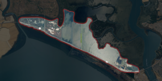
| Description | USGS aerial imagery of an island in the w:San Francisco Bay Area. Background for this highlight images is black at 85% opacity, outline is 15px outside selection border, pure red at 15% opacity. Boundaries taken from USGS survey maps (1913 through 2018), reclamation district documents, and county files. | |||
| Source | NASA tool at worldwind.earth, USGS Topo Imagery map layer | |||
| Author | USGS, self | |||
| Permission (Reusing this file) |
|
Licensing
This file is licensed under the Creative Commons Attribution-Share Alike 4.0 International license.
- You are free:
- to share – to copy, distribute and transmit the work
- to remix – to adapt the work
- Under the following conditions:
- attribution – You must give appropriate credit, provide a link to the license, and indicate if changes were made. You may do so in any reasonable manner, but not in any way that suggests the licensor endorses you or your use.
- share alike – If you remix, transform, or build upon the material, you must distribute your contributions under the same or compatible license as the original.
File history
Click on a date/time to view the file as it appeared at that time.
| Date/Time | Thumbnail | Dimensions | User | Comment | |
|---|---|---|---|---|---|
| current | 22:48, 26 February 2021 | | 3,000 × 1,500 (3.71 MB) | JPxG | == {{int:filedesc}} == {{Information |Description=USGS aerial imagery of an island in the w:San Francisco Bay Area. Background for this highlight images is black at 85% opacity, outline is 15px outside selection border, pure red at 15% opacity. Boundaries taken from USGS survey maps (1913 through 2018), reclamation district documents, and county files. |Source=NASA tool at worldwind.earth, USGS Topo Imagery map layer |Date= |Author=USGS, self |Permission={{PD-USGov-USGS}} |other_versions... |
File usage
The following pages on the English Wikipedia use this file (pages on other projects are not listed):