
File:Nautz1827.jpg

Original file (2,312 × 1,680 pixels, file size: 2.74 MB, MIME type: image/jpeg)
| This is a file from the Wikimedia Commons. Information from its description page there is shown below. Commons is a freely licensed media file repository. You can help. |
Summary
| Description |
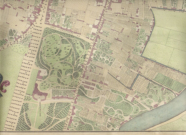
Southern portion of Nautz 1829 map of Haarlem showing Welgelegen as it was in 1827. Map date: 1829 Colored copper engraving by W.C. van Baarsel in Amsterdam. Source: Ferdinand Joseph Nautz(1785-1841) surveyor. Nautz was a member of a group of surveyors hired in 1817 to map the Dutch towns in order serve as a basis for taxes. The hand-colored and hand-drawn maps were created in 1822 by Nautz and his colleagues H.C. van Dooren and A. van Diggelen. They are in the possession of the National Archives. For the town of Haarlem, Nautz created a set of maps of Haarlem where not only ownership rights, but also houses were drawn. Quite popular, these maps were reproduced by book sellers and sold at the time for 3 guilders to travelers as the first city-maps. This set of maps belongs to the city of Haarlem, and has been used as the basis for city planning as late as 1900. In the archive museum of Haarlem, a model of the city is on show based on this map. |
||||||||||||||||
| Date |
Archiefdienst voor Kennemerland/Historische Museum Zuid-Kennemerland, Haarlem |
||||||||||||||||
| Source | Own work Scanned from 2002 reproduction of one of many copies of the 'Nautz of Haarlem' in possession of North Holland Archives. | ||||||||||||||||
| Author |
|
||||||||||||||||
Licensing
|
This work is in the public domain in its country of origin and other countries and areas where the copyright term is the author's life plus 70 years or fewer.
| |
| This file has been identified as being free of known restrictions under copyright law, including all related and neighboring rights. | |
File history
Click on a date/time to view the file as it appeared at that time.
| Date/Time | Thumbnail | Dimensions | User | Comment | |
|---|---|---|---|---|---|
| current | 15:22, 22 January 2007 | | 2,312 × 1,680 (2.74 MB) | Jane023 | == Summary == Southern portion of Nautz 1829 map showing Welgelegen as it was in 1827 1829 Colored copper engraving by W.C. van Baarsel in Amsterdam. Source: Ferdinand Joseph Nautz(1785-1841) surveyor Nautz was a member of a group of surveyors hired in 18 |
File usage
Global file usage
The following other wikis use this file:
- Usage on de.wikipedia.org
- Usage on he.wikisource.org
- Usage on uz.wikipedia.org