
File:New York District 20 109th US Congress.png
Size of this preview: 800 × 465 pixels. Other resolutions: 320 × 186 pixels | 640 × 372 pixels | 1,028 × 597 pixels.
Original file (1,028 × 597 pixels, file size: 246 KB, MIME type: image/png)
| This is a file from the Wikimedia Commons. Information from its description page there is shown below. Commons is a freely licensed media file repository. You can help. |
Summary
| Description |
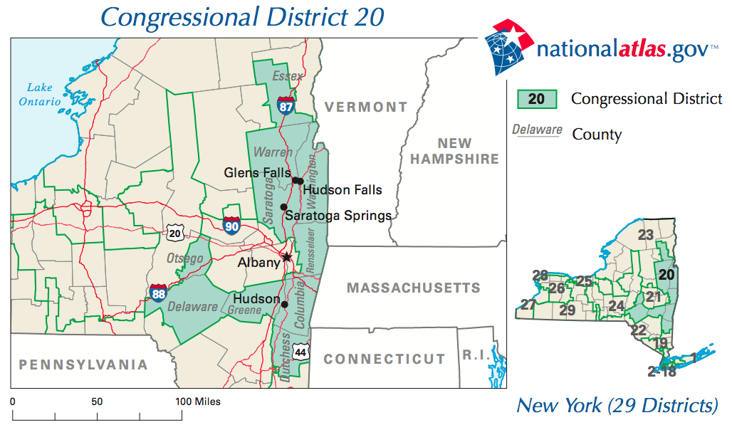
English: Map of New York's 20th congressional district during the 112th Congress. The district is currently represented by Chris Gibson. |
| Date | |
| Source | New York District 20 Map (PDF). National Atlas of the United States. United State Department of the Interior (Unknown date). Retrieved on 2009-09-06. |
| Author | United State Department of the Interior |
Licensing
This map was obtained from an edition of the National Atlas of the United States. Like almost all works of the U.S. federal government, works from the National Atlas are in the public domain in the United States.
Online access: NationalAtlas.gov | 1970 print edition: Library of Congress, Perry-Castañeda Library
|

|
This work includes material that may be protected as a trademark in some jurisdictions. If you want to use it, you have to ensure that you have the legal right to do so and that you do not infringe any trademark rights. See our general disclaimer. This tag does not indicate the copyright status of the attached work. A normal copyright tag is still required. See Commons:Licensing. |
File history
Click on a date/time to view the file as it appeared at that time.
| Date/Time | Thumbnail | Dimensions | User | Comment | |
|---|---|---|---|---|---|
| current | 00:06, 7 September 2009 | | 1,028 × 597 (246 KB) | MattWade | Higher-res version |
| 16:36, 13 September 2007 |  | 636 × 380 (31 KB) | BetacommandBot | Transwiki approved by: w:en:User:Dmcdevit This image was copied from wikipedia:en. The original description was: __NOTOC__ == Summary == 109th US Congress, NY District 20 from http://nationalatlas.gov/printable/images/preview/congdist/ny20_109.gif = |
File usage
The following pages on the English Wikipedia use this file (pages on other projects are not listed):
Global file usage
The following other wikis use this file:
- Usage on es.wikipedia.org
- Usage on ka.wikipedia.org
- Usage on zh.wikipedia.org