
File:New York Subway Map Alargule.svg

Size of this PNG preview of this SVG file: 549 × 600 pixels. Other resolutions: 220 × 240 pixels | 439 × 480 pixels | 703 × 768 pixels | 937 × 1,024 pixels | 1,875 × 2,048 pixels | 1,409 × 1,539 pixels.
Original file (SVG file, nominally 1,409 × 1,539 pixels, file size: 1.84 MB)
| This is a file from the Wikimedia Commons. Information from its description page there is shown below. Commons is a freely licensed media file repository. You can help. |
Summary
| Description |
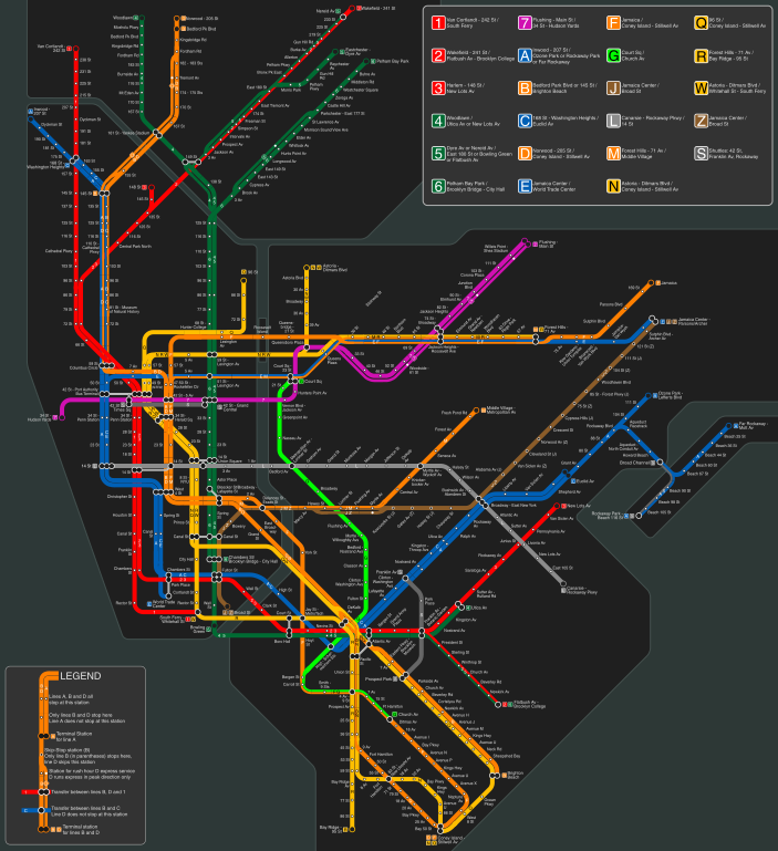
English: Schematic map of the New York Subway system
Nederlands: Schematische plattegrond van de metro van New York |
| Date | |
| Source | Own work |
| Author | Alargule |
Licensing
I, the copyright holder of this work, hereby publish it under the following licenses:
This file is licensed under the Creative Commons Attribution-Share Alike 3.0 Unported license.
- You are free:
- to share – to copy, distribute and transmit the work
- to remix – to adapt the work
- Under the following conditions:
- attribution – You must give appropriate credit, provide a link to the license, and indicate if changes were made. You may do so in any reasonable manner, but not in any way that suggests the licensor endorses you or your use.
- share alike – If you remix, transform, or build upon the material, you must distribute your contributions under the same or compatible license as the original.

|
Permission is granted to copy, distribute and/or modify this document under the terms of the GNU Free Documentation License, Version 1.2 or any later version published by the Free Software Foundation; with no Invariant Sections, no Front-Cover Texts, and no Back-Cover Texts. A copy of the license is included in the section entitled GNU Free Documentation License. |
You may select the license of your choice.
File history
Click on a date/time to view the file as it appeared at that time.
| Date/Time | Thumbnail | Dimensions | User | Comment | |
|---|---|---|---|---|---|
| current | 06:22, 22 December 2016 | | 1,409 × 1,539 (1.84 MB) | Alargule | Added Q train extension to 96 St |
| 06:55, 7 November 2016 |  | 1,409 × 1,539 (1.84 MB) | Alargule | Added W train. | |
| 18:46, 15 September 2015 |  | 1,409 × 1,516 (1.81 MB) | Alargule | 7 extension included | |
| 09:01, 21 August 2012 |  | 1,409 × 1,516 (4.24 MB) | Alargule | Corrected 138 St error. Smoothed out Harlem river. | |
| 22:02, 20 August 2012 |  | 1,409 × 1,516 (4.24 MB) | Alargule | Darker background, smoother 90 degree curves, different layout of the Woodlawn (4) line in the Bronx, resulting in a lower overall height of the map. | |
| 14:46, 19 March 2011 |  | 1,409 × 1,549 (4.23 MB) | Alargule | Renaming of the new E,G,M,7 transfer complex into "Court Sq". Corrected name of G line's Queens terminus (Court Sq instead of Court St). | |
| 19:51, 13 December 2010 |  | 1,409 × 1,549 (4.24 MB) | Alargule | Some minor error corrections; added more line labels. | |
| 12:12, 12 December 2010 |  | 1,409 × 1,549 (4.22 MB) | Alargule | As it turns out, the MTA had another trick up its sleeve yesterday (Dec 10, 2010): the renaming of the "Broadway/Nassau St" station on the A/C lines to "Fulton St". I've used that to my advantage: now the map displays this station complex as one station, | |
| 19:51, 10 December 2010 |  | 1,409 × 1,549 (3.63 MB) | Alargule | I somehow always liked it better with a dark background. Updated the map with the new transfer complex "Jay St/Metrotech", incorporating the former Jay St (A,C,F) and Lawrence St (R) stations. The Myrtle Ave line between Marcy Ave and Myrtle Ave is now | |
| 15:52, 10 November 2010 |  | 1,409 × 1,549 (4.4 MB) | Alargule | Revised the layout of Downtown Manhattan, to create more space for the station names to fit in. Also removed some unnecessary kinks in the Eighth Avenue and Seventh Avenue lines in Downtown Manhattan. Changed the layout of the Broadway/Lafayette-Bleecker |
File usage
The following pages on the English Wikipedia use this file (pages on other projects are not listed):
Global file usage
The following other wikis use this file:
- Usage on ja.wikipedia.org
- Usage on nl.wikipedia.org