
File:Old Madison Vocational School, Carroll Street, Madison, WI (52733878691).jpg

Size of this preview: 800 × 600 pixels. Other resolutions: 320 × 240 pixels | 640 × 480 pixels | 1,024 × 768 pixels | 1,280 × 960 pixels | 2,560 × 1,920 pixels | 4,032 × 3,024 pixels.
Original file (4,032 × 3,024 pixels, file size: 6.15 MB, MIME type: image/jpeg)
| This is a file from the Wikimedia Commons. Information from its description page there is shown below. Commons is a freely licensed media file repository. You can help. |
.jpg)
Summary
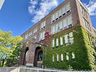
| Description | Built in 1921, this Tudor Revival-style building was designed by Kronenberg Ferdinand, and saw a major addition in 1950 and another in 1964 under the direction of Law, Law, Potter and Nystrom. The school was once adjacent to Madison Central High School, located to the rear of the building, with the school becoming known as the Madison Area Technical College in 1967, and opened a new campus in a more suburban location in 1987, which eventually led to the closure of their original downtown campus. The building is clad in red brick with a limestone base and window trim, large window openings, a limestone surround with doric columns, an architrave with triglyphs, a cornice with dentils, and an arch at the front entrance, niches on either side of the entrance, and an iron railing above the entrance, a six-story addition to the southeast of the original structure, which features a boxy massing and simpler detailing, an entrance porch on the northwest facade with arched openings, brick pillars, a stone relief, and iron railings, a low-slope roof enclosed by a parapet, a curtain wall on the rear of the building with a greenhouse-like entrance, a rear parking garage, and an entrance for the original Central High School that once stood to the rear of the building standing alone at the far end of the parking garage, which matches the front entrance on the old vocational school. The building was listed on the Wisconsin State Register of Historic Places in 2018 and on the National Register of Historic Places in 2019. As of 2023, it is undergoing renovations to be adaptively reused as a hotel. |
| Date | |
| Source | Old Madison Vocational School, Carroll Street, Madison, WI |
| Author | Warren LeMay from Covington, KY, United States |
| Camera location | | View this and other nearby images on: OpenStreetMap |
|---|
.jpg¶ms=043.076061_N_-089.388106_E_globe:Earth_type:camera_source:Flickr_&language=en)
Licensing
This file is licensed under the Creative Commons Attribution-Share Alike 2.0 Generic license.
- You are free:
- to share – to copy, distribute and transmit the work
- to remix – to adapt the work
- Under the following conditions:
- attribution – You must give appropriate credit, provide a link to the license, and indicate if changes were made. You may do so in any reasonable manner, but not in any way that suggests the licensor endorses you or your use.
- share alike – If you remix, transform, or build upon the material, you must distribute your contributions under the same or compatible license as the original.
| This image was originally posted to Flickr by w_lemay at https://flickr.com/photos/59081381@N03/52733878691. It was reviewed on 19 May 2023 by FlickreviewR 2 and was confirmed to be licensed under the terms of the cc-by-sa-2.0. |
File history
Click on a date/time to view the file as it appeared at that time.
| Date/Time | Thumbnail | Dimensions | User | Comment | |
|---|---|---|---|---|---|
| current | 05:37, 19 May 2023 | | 4,032 × 3,024 (6.15 MB) | SecretName101 | Transferred from Flickr via #flickr2commons |
File usage
The following pages on the English Wikipedia use this file (pages on other projects are not listed):
.jpg)