
File:Ontario 71 map.svg

Size of this PNG preview of this SVG file: 800 × 474 pixels. Other resolutions: 320 × 190 pixels | 640 × 380 pixels | 1,024 × 607 pixels | 1,280 × 759 pixels | 2,560 × 1,518 pixels | 1,027 × 609 pixels.
Original file (SVG file, nominally 1,027 × 609 pixels, file size: 722 KB)
| This is a file from the Wikimedia Commons. Information from its description page there is shown below. Commons is a freely licensed media file repository. You can help. |
Summary
| Description |
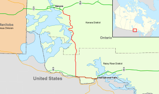
Map of w:Ontario Highway 71 Ontario Highway 71
Ontario Highways / Trans-Canada Highway
Other roads |
| Date | |
| Source | Land, roads, and cities |
| Author | Fredddie |
Licensing
I, the copyright holder of this work, hereby publish it under the following licenses:
This file is licensed under the Creative Commons Attribution-Share Alike 3.0 Unported license.
- You are free:
- to share – to copy, distribute and transmit the work
- to remix – to adapt the work
- Under the following conditions:
- attribution – You must give appropriate credit, provide a link to the license, and indicate if changes were made. You may do so in any reasonable manner, but not in any way that suggests the licensor endorses you or your use.
- share alike – If you remix, transform, or build upon the material, you must distribute your contributions under the same or compatible license as the original.

|
Permission is granted to copy, distribute and/or modify this document under the terms of the GNU Free Documentation License, Version 1.2 or any later version published by the Free Software Foundation; with no Invariant Sections, no Front-Cover Texts, and no Back-Cover Texts. A copy of the license is included in the section entitled GNU Free Documentation License. |
You may select the license of your choice.
File history
Click on a date/time to view the file as it appeared at that time.
| Date/Time | Thumbnail | Dimensions | User | Comment | |
|---|---|---|---|---|---|
| current | 22:58, 11 January 2014 | | 1,027 × 609 (722 KB) | Floydian | fix whacky stray lines |
| 22:41, 11 January 2014 |  | 1,027 × 609 (722 KB) | Floydian | Adjust position of inset | |
| 22:35, 11 January 2014 |  | 1,027 × 609 (723 KB) | Floydian | Add inset, adjust colours to Ontario standards | |
| 04:56, 3 January 2014 |  | 1,027 × 609 (297 KB) | Fredddie | {{Information |Description=Map of w:Ontario Highway 71<br> {{legend||line=2px solid #ff0|Ontario Highway 71}} {{legend||line=1px solid #38a800|Trans-Canada Highway}} |Source=|Source=[http://www.gadm.org/country Land], [http://www.naturalearthdata.c... |
File usage
The following pages on the English Wikipedia use this file (pages on other projects are not listed):
Global file usage
The following other wikis use this file:
- Usage on www.wikidata.org