
File:Ordnance Survey Drawings - Portsmouth (OSD 75-3).jpg

Size of this preview: 704 × 599 pixels. Other resolutions: 282 × 240 pixels | 564 × 480 pixels | 902 × 768 pixels | 1,203 × 1,024 pixels | 2,405 × 2,048 pixels | 4,000 × 3,406 pixels.
Original file (4,000 × 3,406 pixels, file size: 5.43 MB, MIME type: image/jpeg)
| This is a file from the Wikimedia Commons. Information from its description page there is shown below. Commons is a freely licensed media file repository. You can help. |
| Portsmouth (OSD 75-3)
|
|||||
|---|---|---|---|---|---|
| Title |
Ordnance Survey Drawings: Portsmouth (OSD 75-3) |
.jpg) | |||
| Object type |
manuscript map |
||||
| Description |
 Centre of map shown on a map of England
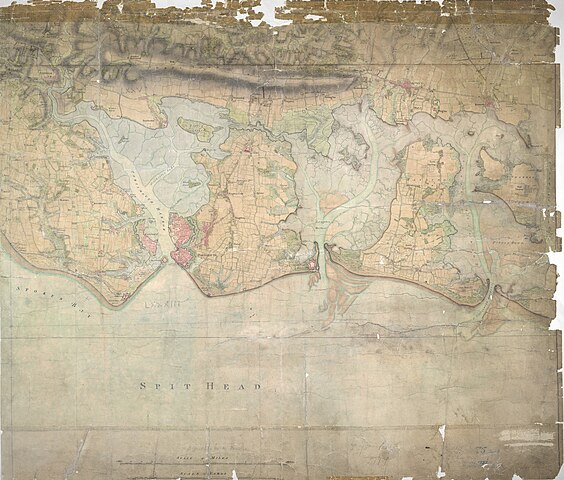
English: This drawing was surveyed in 1797, the year Napoleon declared that France "must destroy the English monarchy, or expect itself to be destroyed by these intriguing and enterprising islanders… Let us concentrate all our efforts on the navy and annihilate England. That done, Europe is at our feet." The detail with which the area is surveyed reflects the danger the English establishment felt. The dockyards of Portsmouth, one of most important naval sites in Britain, are shown by red blocks. The defence fortifications of the area are clearly delineated. South Sea Castle, one of the defensive forts built on the south coast by Henry VIII, is shown in plan form..
This image has been georeferenced.
|
||||
| Language |
English |
||||
| Date | 1797 | ||||
| Medium | Pen and ink on paper | ||||
| Collection | |||||
| Accession number |
Maps OSD 75-3 |
||||
| Credit line | British Library | ||||
| Notes |
Scale 3 inches : 1 mile (1:21120). Please note that the British Library provides these digital files "as-is"; materials will not be rephotographed under this programme. If resupply of files is required, the requestor will be required to purchase them at the standard rate. |
||||
| References |
http://www.bl.uk/onlinegallery/onlineex/ordsurvdraw/p/002osd000000015u00345000.html (English) |
||||
| Source/Photographer |
|
||||
| Permission (Reusing this file) |
|
||||


_(St_Edwards_Crown).svg)
.jpg)
.jpg¶ms=50.797122_N_-1.04908_E_)
.jpg¶ms=50.712355_N_-1.205341_E_)
.jpg¶ms=50.881889_N_-0.892819_E_)
.jpg¶ms=50.879904_N_-1.205341_E_)
.jpg¶ms=50.712355_N_-1.203384_E_)
.jpg¶ms=50.714339_N_-0.892819_E_)
.jpg¶ms=50.881889_N_-0.894776_E_)
File history
Click on a date/time to view the file as it appeared at that time.
| Date/Time | Thumbnail | Dimensions | User | Comment | |
|---|---|---|---|---|---|
| current | 20:36, 28 September 2013 | | 4,000 × 3,406 (5.43 MB) | LibraryBot | {{subst:User:Andrew Gray/OSD|ID= 002OSD000000015U00345000 |OSD_NUM= OSD 75-3 |MEDIUM= Pen and ink on paper |TITLE= Portsmouth |CREATOR= |YEAR= 1797 |DESCRIPTION= This drawing was surveyed in 1797, the year Napoleon declared that France "must destroy t... |
File usage
The following pages on the English Wikipedia use this file (pages on other projects are not listed):
Global file usage
The following other wikis use this file:
- Usage on www.wikidata.org
.jpg)