
File:Oregon Country map-fr.svg

Size of this PNG preview of this SVG file: 546 × 600 pixels. Other resolutions: 218 × 240 pixels | 437 × 480 pixels | 699 × 768 pixels | 932 × 1,024 pixels | 1,864 × 2,048 pixels.
Original file (SVG file, nominally 932 × 1,024 pixels, file size: 4.57 MB)
| This is a file from the Wikimedia Commons. Information from its description page there is shown below. Commons is a freely licensed media file repository. You can help. |
| Description |
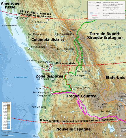
Français : Carte de l'Oregon Country et du territoire disputé en 1818 - 1846. English: Map showing Oregon Country and disputed area in 1818 - 1846. Deutsch: Karte zum Oregon Country. |
||
| Date | |||
| Source |
English: Own work with data from File:Oregoncountry.png by User:Kmusser;
Français : Création personnelle à partir de File:Oregoncountry.png par User:Kmusser ;
|
||
| Author | Bourrichon - fr:Bourrichon | ||
| Permission (Reusing this file) |
I, the copyright holder of this work, hereby publish it under the following license: This file is licensed under the Creative Commons Attribution-Share Alike 3.0 Unported, 2.5 Generic, 2.0 Generic and 1.0 Generic license.
|
.svg)

|
This SVG file contains embedded text that can be translated into your language, using any capable SVG editor, text editor or the SVG Translate tool. For more information see: About translating SVG files. |
This W3C-unspecified vector image was created with Inkscape .
File history
Click on a date/time to view the file as it appeared at that time.
| Date/Time | Thumbnail | Dimensions | User | Comment | |
|---|---|---|---|---|---|
| current | 13:07, 27 March 2010 | | 932 × 1,024 (4.57 MB) | Bourrichon | {{Information |Description= {{fr|Carte de l'fr:Oregon Country et du territoire disputé en 1818 - 1846.}}{{en|Map showing en:Oregon Country and disputed area in 1818 - 1846.}}{{de|Karte zum de:Oregon Country.}} |Source= {{en|Own work ; |
File usage
The following pages on the English Wikipedia use this file (pages on other projects are not listed):
Global file usage
The following other wikis use this file:
- Usage on es.wikipedia.org
- Usage on fr.wikipedia.org
- Usage on it.wikipedia.org
- Usage on pt.wikipedia.org
- Usage on ru.wikipedia.org
- Usage on vi.wikipedia.org