
File:Place Montreal 1675.jpg

Original file (1,600 × 1,184 pixels, file size: 288 KB, MIME type: image/jpeg)
| This is a file from the Wikimedia Commons. Information from its description page there is shown below. Commons is a freely licensed media file repository. You can help. |
Summary
| Description |
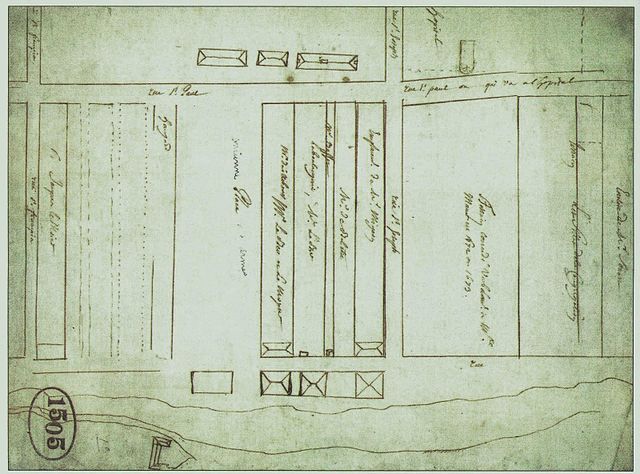
English: Plan of Montreal, circa 1675
Français : Plan anonyme et non daté du secteur de la première place publique de Montréal, vers 1675. À gauche de la place, un « hangard », trois allées qui étaient bordées de « boutiques volantes » et la peopriété de Jacques LeMoyne. En bas, la pointe à Callière avec le « château » du fort appelé à disparaître. En haut, trois bâtiments, dont le premier séminaire des sulpiciens et la maison LeMoyne-LeBer. |
| Date | circa 1675 |
| Source | Archives des Prêtres de Saint-Sulpice de Montréal / repris dans : L'histoire du Vieux-Montréal à travers son patrimoine, sous la direction de Gilles Lauzon et Madeleine Forget, Les publications du Québec, Sainte-Foy, 2004, p. 44. |
| Author | Anonymous |
Licensing
|
This work is in the public domain in its country of origin and other countries and areas where the copyright term is the author's life plus 70 years or fewer.
| |
| This file has been identified as being free of known restrictions under copyright law, including all related and neighboring rights. | |
File history
Click on a date/time to view the file as it appeared at that time.
| Date/Time | Thumbnail | Dimensions | User | Comment | |
|---|---|---|---|---|---|
| current | 23:34, 27 November 2009 | | 1,600 × 1,184 (288 KB) | Jeangagnon | plus haute résolution |
| 21:26, 27 November 2009 |  | 787 × 590 (71 KB) | Jeangagnon | {{Information |Description={{en|1=Plan of Montreal, circa 1675}} {{fr|1=Plan anonyme et non daté du secteur de la première place publique de Montréal, vers 1675. À gauche de la place, un « hangard », trois allées qui étaient bordées de « boutiqu |
File usage
Global file usage
The following other wikis use this file:
- Usage on fr.wikipedia.org