
File:Political map of the Levant, circa 1085.png
Size of this preview: 582 × 599 pixels. Other resolutions: 233 × 240 pixels | 466 × 480 pixels | 991 × 1,020 pixels.
Original file (991 × 1,020 pixels, file size: 547 KB, MIME type: image/png)
| This is a file from the Wikimedia Commons. Information from its description page there is shown below. Commons is a freely licensed media file repository. You can help. |
Summary
| Description |
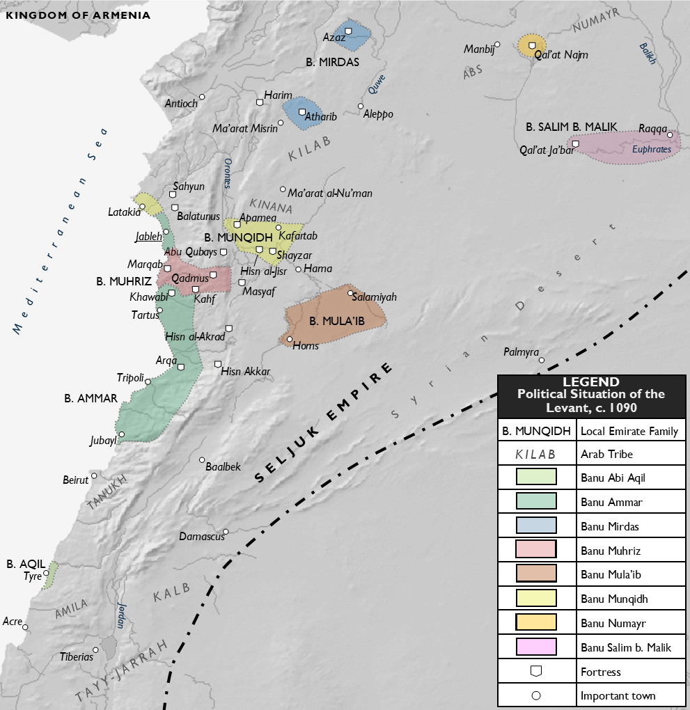
English: A map of the political situation in the Levant around 1085. |
| Date | |
| Source | Own work |
| Author | Al Ameer son |
| Other versions | العربيَّة |
Licensing
I, the copyright holder of this work, hereby publish it under the following license:
This file is licensed under the Creative Commons Attribution-Share Alike 4.0 International license.
- You are free:
- to share – to copy, distribute and transmit the work
- to remix – to adapt the work
- Under the following conditions:
- attribution – You must give appropriate credit, provide a link to the license, and indicate if changes were made. You may do so in any reasonable manner, but not in any way that suggests the licensor endorses you or your use.
- share alike – If you remix, transform, or build upon the material, you must distribute your contributions under the same or compatible license as the original.
File history
Click on a date/time to view the file as it appeared at that time.
| Date/Time | Thumbnail | Dimensions | User | Comment | |
|---|---|---|---|---|---|
| current | 22:06, 24 November 2020 | | 991 × 1,020 (547 KB) | Al Ameer son | Correct placement of the Kilab |
| 21:54, 24 November 2020 |  | 991 × 1,020 (548 KB) | Al Ameer son | Add Banu Mirdas of Azaz and Atharib, Bani Abi Aqil of Tyre, change date to 1090, minor changes | |
| 20:22, 19 November 2020 |  | 987 × 1,013 (540 KB) | Al Ameer son | Fix error (Banu Muhriz name) | |
| 20:15, 19 November 2020 |  | 987 × 1,013 (539 KB) | Al Ameer son | Expand Banu Ammar territory to span Tartus and Arqa | |
| 18:49, 19 November 2020 |  | 986 × 1,012 (538 KB) | Al Ameer son | Expand Banu Ammar territory to include Khawabi | |
| 17:14, 19 November 2020 |  | 987 × 1,017 (538 KB) | Al Ameer son | Rmv bold from emirate names | |
| 17:04, 19 November 2020 |  | 987 × 1,015 (536 KB) | Al Ameer son | Cropped, enlarged script, other modifications | |
| 22:36, 18 November 2020 |  | 1,213 × 1,265 (695 KB) | Al Ameer son | Uploaded own work with UploadWizard |
File usage
The following pages on the English Wikipedia use this file (pages on other projects are not listed):
Global file usage
The following other wikis use this file:
- Usage on fa.wikipedia.org
- Usage on pt.wikipedia.org