
File:Porter1796WesternReserve-300.jpg

Size of this preview: 800 × 534 pixels. Other resolutions: 320 × 213 pixels | 640 × 427 pixels | 1,024 × 683 pixels | 1,280 × 854 pixels | 2,560 × 1,707 pixels | 7,403 × 4,937 pixels.
Original file (7,403 × 4,937 pixels, file size: 6.67 MB, MIME type: image/jpeg)
| This is a file from the Wikimedia Commons. Information from its description page there is shown below. Commons is a freely licensed media file repository. You can help. |
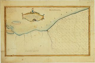
| Description | A Plan of the Survey made by & under the direction of Augustus Porter upon the Connecticut-Reserve for the Connecticut Land Company in the Year 1796. Showing the Western Reserve divided into sections and the town and city of Cleaveland (Cleveland) |
| Date | |
| Source | William L. Clements Library (University of Michigan) |
| Author | Augustus Porter |
| Other versions | http://www.railsandtrails.com/Maps/Porter1796WesternReserve/index.htm |
|
This work is in the public domain in its country of origin and other countries and areas where the copyright term is the author's life plus 100 years or fewer. | |
| This file has been identified as being free of known restrictions under copyright law, including all related and neighboring rights. | |
File history
Click on a date/time to view the file as it appeared at that time.
| Date/Time | Thumbnail | Dimensions | User | Comment | |
|---|---|---|---|---|---|
| current | 23:43, 13 October 2010 | | 7,403 × 4,937 (6.67 MB) | Scewing | {{Information |Description=A Plan of the Survey made by & under the direction of Augustus Porter upon the Connecticut-Reserve for the Connecticut Land Company in the Year 1796. Showing the Western Reserve divided into sections and the town and city of Cle |
File usage
The following pages on the English Wikipedia use this file (pages on other projects are not listed):
Global file usage
The following other wikis use this file:
- Usage on ja.wikipedia.org
- Usage on zh.wikipedia.org